
Salvador is the capital of the state of Bahia, in the northeast of Brazil. the city went to first capital of Brazil, a function he performed between 1549 and 1763.
It currently has a population of 2.8 million inhabitants, making it the fourth most populous city in Brazil and the largest in the region. The tertiary sector leads the Salvadoran economy, with a large share of the tourist sector.
Read too: What are the capitals of Brazilian states?
Salvador general data
Gentile: Salvadoran
Location: Northeast region
Parents: Brazil
Federative unit: Bahia
Intermediate region: savior
Immediate region: savior
-
Metropolitan region: Metropolitan Region of Salvador, comprising 13 municipalities:
Salvador, Camaçari, Candeias, Dias D'Ávila, Itaparica, Lauro de Freitas, Madre de Deus, Mata de São João, Pojuca, Salvador, São Francisco do Conde, São Sebastião do Passé, Simões Filho, Vera Cruz.
Bordering municipalities: Lauro de Freitas, Simões Filho, Candeias, Madre de Deus, Itaparica, Vera Cruz.
-
geography
- Total area: 693,453 km² (IBGE, 2020)
- Total population: 2,886,698 inhabitants (IBGE, 2020)
- Density: 3,859.44 inhab./km² (IBGE, 2010)
- Climate: Tropical
- Altitude: 12 meters
- Time zone: GMT -3
-
Historic
- Foundation: March 29, 1549
Do not stop now... There's more after the advertising ;)
Salvador geography
Salvador is a Brazilian city located on the northeast coast of the country, belonging to the state of Bahia. The municipality houses the seat of the state government of Bahia. Furthermore, it was the first Brazilian capital when the country was still a colony of Portugal.
the city is located in the Bay of All Saints, in the Recôncavo Baiano, with exit to the Atlantic Ocean both east and west. It separates from the island of Itaparica, to the southwest, by the Salvador channel, and establishes a physical boundary with the municipalities of Lauro de Freitas and Simões Filho. Its surface covers 693,453 km², an area considerably small compared to other cities in Bahia.
In 1973, the Metropolitan Region of Salvador was created, initially formed by eight municipalities. Currently, in addition to the capital of Bahia, the RMS is made up of 12 municipalities.
Salvador climate
The predominant climate in Salvador is the hot and humid tropical. It is characterized by high temperatures most of the year, including winter months, and high relative humidity. The average temperature is around 25.5°C, with lows that are often above the range that goes from 18°C to 22°C.
The city does not have a dry season, with rainfall amounting to approximately 1300 mm per year. The largest volumes of rain are registered between the months of March and August, therefore, autumn and Winter, which is due to the influence of current atmospheric systems.
See too: What is the difference between weather and climate?
Salvador relief
The city of Salvador belongs to the domain of plains and coastal lowlands, according to the classification proposed by Aziz Ab’Sáber. Despite this, the plain areas are considerably narrow, and the city is marked by the presence of an extensive geological fault, denominated fsavior's flap, which divides it into Cidade Alta and Cidade Baixa.
In total, the fault tailings are six kilometers long, but over time, the accumulation of sediments left an unevenness of80 meters between the highest and the lowest part, which can be observed through the escarpment constituted by the fault plane. Movements between one part and another are made by various means, including the Elevador Lacerda, built in the late nineteenth century.

Vegetation of Salvador
The Salvadoran vegetation cover is part of the biome Atlantic forest, with the city located in the Northeastern Zona da Mata. Thus, part of the vegetation is formed by the characteristic species of the dense tropical forest. The city is also part of the Brazilian coastal-marine system, composed of vegetation typical of humid areas, such as dunes, mangroves and restingas.
Salvador hydrography
O Camarajipe river it is the main watercourse that bathes the Bahian capital. In addition to it, its tributaries (Campinas, Pernambués and Tripas) and the Pedras, Cobre, Jaguaribe, Seixos, Paraguari and Passa-Vaca rivers as part of the Salvador drainage network.
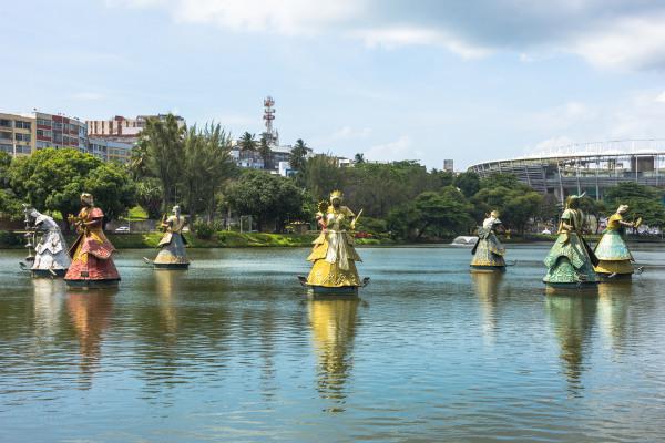
Among the city's lakes and lagoons, are the Abaeté Lagoon, Pituaçu Lagoon and the dwhat do Tororó. The latter has great artistic and cultural value for the metropolis of Bahia, since it is where the Fonte do Dique do Tororó, considered a heritage of Bahia, and the famous sculptures of the Orixás placed in a circle over the waters.
Salvador map
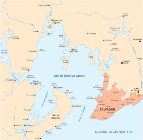
Salvador is located on the north coast of the state of Bahia, as shown in the image below.

In the image below, we have a map at a closer scale of part of the Recôncavo Baiano and Baía de Todos os Santos. The capital of Bahia can be seen in the lower right portion, highlighted in a darker color.
Salvador Demographics
savior is the most populous city in Bahia and the fourth in the Brazil, behind only São Paulo, Rio de Janeiro and Brasilia. It has 2,886,698 inhabitants or 19.33% of the population of Bahia. Its metropolitan region is the third largest in the Northeast region after Fortaleza and Recife, totaling 3.89 million inhabitants. Salvador, in addition to being a populous municipality, is densely populated. The population distribution, according to the 2010 Census, is 3,859.44 inhab./km².
A very small portion of Salvador's residents (0.02%) live in rural areas of the city, with the vast majority in urbanized areas. Regarding population composition, Salvador stands out for the number of self-declared brown and black people. The sum of these two groups is equivalent to 79.47% of the Salvadoran population. Whites are 18.9%, yellows 1.34%, and indigenous people represent 0.28% of the residents of the capital of Bahia.
THE age pyramid at the time of the 2010 Census reveals a pretty young population, with a large concentration in the range of 24 to 29 years of age, a scenario that has been undergoing transformation as the average age of the population increases and the process of population-ageing.
Check out our podcast: What do I need to know about demographic theories?
Salvador geographic division
The city of Salvador is subdivided into 170 neighborhoods since the year 2020, when seven new units were established.
the neighborhoods do part of 10 many different formeals-Bairros, which, in certain places, are referred to as boroughs. As described by the government of Salvador itself, these units have a representative character and aim at the best management of each area of the city, promoting its more effective articulation with the central power, which is the town hall.
Salvador Economy
The city of Salvador is one of the main economic centers in Bahia. Your Gross Domestic Product (GDP) totals R$ 63.52 billion, with the 10th largest municipal amount in the entire Brazilian territory. The GDP per capita of the capital of Bahia is equivalent to R$ 22,232, a very low value both in the national and state scenarios. In absolute terms, Salvador ranks fifth on the list of Brazilian capitals in number of people living below the poverty line|1|.
Considering the sectorial participation in Salvador's economy, the activities of the tertiary, with the exception of the public administration for this calculation, are the ones that have the best performance.. We highlight here the wide participation of tourism, since the capital of Bahia represents one of the main destinations in the Northeast region, with attractions ranging from the countless beaches, places and historical monuments to traditional celebrations and events, such as the Carnival, which attracts national and international tourists.
The Metropolitan Region of Salvador houses the main industries of Bahia, as is the case of Polo de Camaçari. In the capital itself, industries of the food, textile, construction, machinery and related sectors. The agricultural sector is the least expressive in relation to GDP, with fruit cultivation standing out.
Salvador Government
Salvador has a government of the type representative democratic. This means that city rulers are elected by their population, which takes place every four years in direct elections. The executive branch of the municipality has the Mayor, while the City Council, which represents the FOROder Legislative, is composed of 43 councilors. The city also plays the role of seat of the government of the state of Bahia.
Salvador Infrastructure
The process of urbanization from Salvador happened very quickly from the mid-twentieth century, resulting in structural problems that remain until the present day, notably in the poorest areas of the city. As we highlighted, the capital of Bahia has a large population living below the poverty line and has high rates of unemployment and informality.
With regard to urban structure, the latest Census of IBGE points to a comprehensive adequate sewage network, which reached 92.8% of the establishments. A similar scenario is drawn up for the service through the water network.
Urban transport is carried out by means of public buses, taxis, subway lines that run through the city and also the Elevador Lacerda, which connects Cidade Alta to Cidade Baixa. This consists of a narrow plain where port services are mainly concentrated, and where it is possible to carry out the sea crossing between neighborhoods in Salvador.
One of the main airports in Bahia is located in the city, the Salvador International Airport (Deputy Luís Eduardo Magalhães). O port of savior, located on its coast, is extremely important for connections between locations and for the transport of commercial cargo.
Salvador culture
The capital of Bahia has a great cultural diversity, influenced by indigenous peoples, Portuguese, migrants from other regions of Brazil and mainly by African peoples. Identifies the African cultural presence in various events, as in music, cooking, dancing and also in religiosity. Salvador is known for the wide spread of African-based religions, such as the different branches of Candomblé and Umbanda, as well as for the presence of traditional centers of these religions.
O religious syncretism is also present in culture Salvador, expressed in traditional festivals and religious events, among which the washing thes Stairs of Bonfim. THE Fis from Yemanja is another well-known celebration and takes place in the month of February. In addition to the various festivals that take place annually, Salvador is recognized for its Carnival, musical genres such as axé and dances such as capoeira.
the city is origin also of many great names in Brazilian popular culture, as in music (Gal Costa, Gilberto Gil, Dorival Caymmi, Raul Seixas), with very varied musical styles, in literature or in the visual arts.
Read too: Definition and characteristics of material culture and immaterial culture
history of savior
THE foundation of the city of Salvador happened in the first century of Portuguese rule in Brazil, in 1549, and it was performed by Tome de Souza. Settlers arrived in the region long before that date, at the beginning of the 16th century. At the time, Todos os Santos Bay was inhabited exclusively by indigenous populations. Salvador became the first capital of Brazil and the economic center of Portuguese America, a phase that lasted until the 18th century, in the year 1763.

The period is marked by the fast and intense city development whose buildings remain today in the landscape of the historic center of Salvador. Even with the transfer of the capital of the then Brazilian empire to the Southeast region, in Rio de Janeiro, the city of Bahia maintained its growth rate. Some of conflicts that marked the history of Salvador, in the 18th and 19th centuries, they are the Bahia Conjuration (1798) and the Malês revolt (1835), in addition to clashes of the war of independence, in the 1820s.
The arrival of the 20th century is characterized by urban reform performed by the then governor Joaquim José Seabra, between 1912 and 1916. A few decades later, following what happened in several other cities in the region, Salvador experienced the rapid growth of its population as a result of the industrialization process. The capital of Bahia is now one of the largest cities in Brazil and economic and political center of Bahia.
Note
|1| Bahia has the largest number of extremely poor people in Brazil, points out IBGE. Afternoon Newspaper, November 12 2020. Available in: https://atarde.uol.com.br/bahia/noticias/2145988-bahia-tem-o-maior-numero-de-pessoas-extremamente-pobres-do-brasil-aponta-ibge.
Image credit
[1] Cassiohabib / Shutterstock
By Paloma Guitarrara
geography teacher