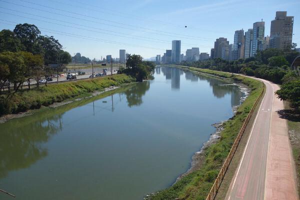
O Tiete river It is one of rivers best known in Brazil. With a vast hydrographic network, it has a great economic and cultural importance, as it is part of the formation process of 62 riverside municipalities that emerged on its margin.
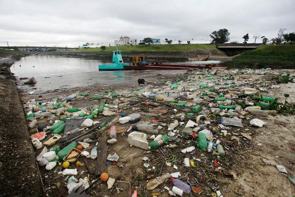
The use of the river is due to the use of its waters for agriculture, livestock and energy generation in some stretches that have plants. It also stands out because of its environmental problems. It is a highly polluted spring and that receives more than two tons of solid waste and sewage daily from the largest national metropolis, São Paulo. This river even has dead stretches, as it has no animal or plant life in certain places.
Read too:Nile River – the longest river in the world in terms of territorial extension
Tietê general data
- Length: 1,100 km and crosses the entire state of São Paulo.
- Source: Salesópolis – SP.
- spring altitude: 1,030 meters.
- Mouth: The Tietê River runs for 1,100 kilometers to the municipality of Itapura, at its mouth on the Paraná River, on the border with Mato Grosso do Sul.
- Main tributaries: Piracicaba river, Jacaré-Pepira river and Sorocaba river.
- Bhydrographic office: The Tietê river bathes 62 riverside municipalities and its basin comprises six hydrographic sub-basins: Alto Tietê, where the metropolitan region of São Paulo is located; Piracicaba; Sorocaba/Médio Tietê; Tietê/Alligator; Tietê/Batalha and Baixo Tietê. Its basin is entirely from São Paulo and covers only the state of São Paulo.

Name origin
The origin of the name of the Tietê river is linked to Brazilian history, as it dates back to Tupi-Guarani. This river was known as Anhembi river, which in Tupi means Anhumas river – a typical bird from the region of the current state of São Paulo. This nomenclature prevailed until the 17th century, when the pioneers called it Tietê, a toponym of indigenous origin that means: you – river and eh – large, deep, true, ie big river or real.
Do not stop now... There's more after the advertising ;)
Tietê river hydrography
The hydrography of the Tietê river is highlighted because it is the main river that passes through the biggest national metropolis, crossing the whole raegion metropolitan from Sao Paulo. It drains into the Paraná River macrobasin, being one of the main tributaries of this hydrographic basin.
Its main source is located in the municipality of salesópolis (SP), at Parque Nascentes do Rio Tietê. This area is under environmental Protection, in an attempt to preserve the sources of the basin. Currently, the park tries to preserve the original fauna and flora of the Atlantic forest, contributing to the existence and support of the river's source.
Tietê also plays an important role in economic development, with navigation, supply, tourism and the presence of hydroelectric plants, such as Pirapora do Bom Jesus and Usina de Rasgão, both responsible for the electrical supply of São Paulo and its surroundings.
This watercourse crosses 62 municipalities in São Paulo and, as it belongs to one of the most densely populated and populated areas in the country, it suffers environmental impacts every day along its riverbed. your basin understands six sub-basins: Alto Tietê, where the metropolitan region of São Paulo is located; Piracicaba; Sorocaba/Médio Tietê; Tietê/Alligator; Tietê/Batalha and Baixo Tietê.
Alto Tietê: area covering the source of the river;
Sorocaba/Middle Tietê: comprises 34 municipalities, of which 17 are in the Médio Tietê sub-basin;
Piracicaba-Capivari-Jundiaí: includes municipalities from São Paulo and Minas Gerais, but the majority (92.6%) is from the state of São Paulo;
Tietê/Battle: covers areas in the cities of Itápolis, Lins, Matão, Novo Horizonte and Taquaritinga;
Tietê/Alligator: covers 34 municipalities, located in the center of the state and passing through cities such as Araraquara, Bauru, Jaú, Lençóis Paulista and São Carlos;
Low Tiete: covers the northwest of the state and extends to the end of the basin, which has its mouth in the Paraná River. There is an emphasis on the city of Andradina.
Read too: Watersheds - what they are, elements, types, examples
Environmental problems on the Tietê river
You environmental problems linked to one of the main rivers in the state of São Paulo have a direct relationship with the city and its overpopulation. The river receives a large volume of industrial sewage in the city of Mogi das Cruzes, 45 km from the source, in addition to what it receives from the national megalopolis (São Paulo), with the dumping of industrial and urban waste in its course in the metropolitan region of São Paulo.

Much of the industrial and urban waste in the city of São Paulo is dumped irregularly into the riverbed. This practice became common due to the absence of a sewage collection network during the period of Brazilian industrialization, from the 1930s to the 1970s. Thus, a common habit at the time was to direct this urban-industrial waste to water courses, such as in the river in question, a practice that is still recurrent today.
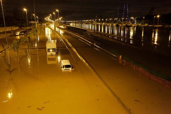
Besides the Water pollution, another important environmental problem around Tietê is the floods. This phenomenon is explained by the expansion of urban areas and the construction of buildings and highways in the vicinity of the lower bed (area of natural flooding).

In the city of São Paulo, the river has in its surroundings the B, one of the main roads of the city and through which about two million cars pass daily. In the rainy season, it is common to occur floods in the area, since millions of liters of water drain quickly into the bed, making the river volume increase suddenly.
Read too: Urban socio-environmental problems
Importance of the Tietê River
Every watercourse has enormous potential when it comes to its economic use, such as the use of water for the agriculture, livestock, domestic activities, energy production, navigation, fishing, among others. Unfortunately, this is not the reality of the Tietê river waters. This river has great limitations due to the high pollution in some parts, as in the metropolitan region of São Paulo, where the presence of oxygen in the river is practically zero and there is no animal or plant life.
However, there are some parts where it occurs electric power generation, with 12 hydroelectric power plants along this river, including the Parque de Salesópolis, Pirapora de Bom Jesus and Rasgão dams.
Another important highlight is the use of water, from the municipality of Barra Bonita, for the Agriculture and Livestock. In this stretch, the water is already clearer and cleaner, which has enabled its use for these purposes.
By Gustavo Henrique Mendonça
Geography teacher


