The relief presents different formations that are consequences of the actions of endogenous agents (result of the energy from the interior of the planet that is manifested by the dynamics or plate tectonics) and exogenous agents (associated with the climate of the area, such as rain, wind and glaciers, which create or give sculptural shapes to the relief through a process erosive).
O brazilian relief it has an ancient formation and results, mainly, from the succession of climatic cycles and from the action of the Earth's internal forces, such as the movement of tectonic plates, faults and volcanism.
There are different classifications of the Brazilian relief, each following a criterion. Among the best known are the one carried out in 1940 by Professor Aroldo Azevedo, who used the altimetric level as a criterion. In the 1950s, professor Aziz Ab'Saber presented a new classification, based on the process of erosion and sedimentation. The most recent classification of the Brazilian relief dates from 1995, elaborated by the professor of the geography department at the University of São Paulo (USP), Jurandyr Ross. His work is based on the Radambrasil project, a survey carried out in the Brazilian territory, between 1970 and 1985, with space radar equipment installed in an airplane. Ross considers 28 relief units, divided into plateaus, plains and depressions.

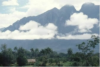
Peak of fog
plateaus – These are high relief forms, with altitudes above 300 meters. They can be found in any type of geological structure. In sedimentary basins, plateaus are characterized by the formation of scarps in areas bordering the depressions. They also form chapadas, extensive flat surfaces at high altitude. At 2,995.30 meters, the peak of Neblina is the highest point in the Brazilian relief.
depressions– These are lowered areas as a result of erosion, which form between sedimentary basins and crystalline shields. Some of the depressions located on the margins of sedimentary basins are called marginal or peripheral depressions. They are present in large numbers in the Brazilian territory and are of various types, such as the Western Amazon depression (land at around 200 meters in altitude).
plains– These are geologically very recent relief units. It is an extremely flat surface, its formation occurs due to the successive deposition of material of marine, lacustrine or fluvial origin in flat areas. They are usually located close to the coast or the courses of large rivers and lakes, such as the plains of Lagoa dos Patos and Lagoa Mirim, on the coast of Rio Grande do Sul.
By Wagner de Cerqueira and Francisco
Graduated in Geography
Brazil School Team
Source: Brazil School - https://brasilescola.uol.com.br/brasil/relevo-brasileiro.htm


