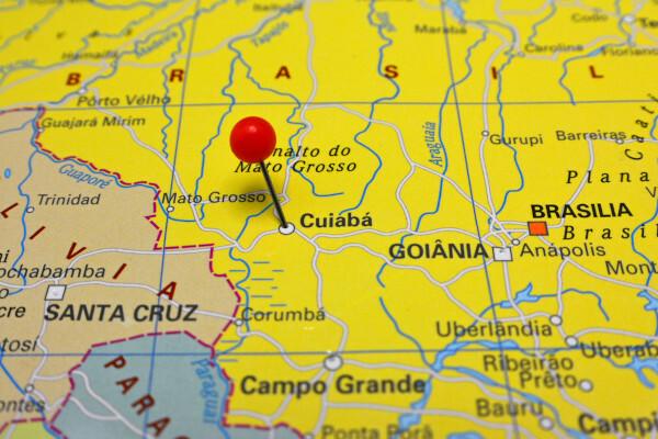
Cuiabá is a Brazilian municipality of Midwest region from the country. plays the role of Mato Grosso state capital. It has a tropical climate, with high temperatures throughout the year, in addition to a relief marked by gently undulating shapes. Today, the city has 618,124 inhabitants and is one of the main economic centers of Mato Grosso, with a large share of the tertiary sector in the economy.
Read too: What are the capitals of Brazilian states?
Summary
Cuiabá is the capital of Mato Grosso, state of the Midwest Region, in addition to housing the Geodesic Center of South America.
It integrates the Metropolitan Region of Vale do Rio Cuiabá and is the most populous city in the state, with 618,124 inhabitants.
It has a tropical continental climate, with rainy summers and dry winters. The maximum temperatures can, in warmer years, exceed 40º C. It has relief that varies from flat to wavy.
Its GDP is R$ 23.7 billion, the highest value in the state. The economy is led by the tertiary sector, followed by industry, which has very different branches (textile, food, extractive, steel, publishing).
It connects with other regions of the country by highways such as the BR-163, in addition to having a dry port of great importance for regional trade.
Among its cultural manifestations is the cururu, a traditional dance from rural areas. The music is played on the handmade viola de cocho.
General data for Cuiabá
Gentile: Cuiaban.
-
Cuiabá Location
Parents: Brazil
Federative unit: Mato Grosso.
Intermediate region[1]: Cuiabá.
Immediate region[1]: Cuiabá.
Metropolitan region: Metropolitan Region of the Cuiabá River Valley. Comprised by the municipalities of Cuiabá, Acorizal, Chapada dos Guimarães, Nossa Senhora do Livramento, Santo Antônio de Leverger and Várzea Grande.
Bordering municipalities: Chapada dos Guimarães, Campo Verde, Santo Antônio do Leverger, Várzea Grande, Acorizal.
-
Cuiabá Geography
Total area: 3,291,696 km² (IBGE, 2020).
Total population: 618,124 inhabitants (IBGE, 2020).
Density: 157.66 inhab./km² (IBGE, 2010).
Climate: continental tropical.
Altitude: 177 meters.
Time zone: GMT -4 hours.
-
Cuiabá History
Foundation: April 8, 1719.
Do not stop now... There's more after the advertising ;)
Cuiabá Geography
Cuiabá is a Brazilian municipality located in the Center-West region of the country and considered a Geodesic Center in South America. It belongs to the state of Mato Grosso and plays the role of capital, as it houses the seat of the state government. It has an area of 3.2 thousand km² and borders five municipalities:
Chapada dos Guimarães, to the north and east;
Campo Verde, to the east;
Santo Antônio do Leverger, to the south;
Várzea Grande and Acorizal, to the west.
The capital of Mato Grosso is part of the Metropolitan Region of Vale do Rio Cuiabá, which is made up, in total, of six municipalities. According to the urban hierarchy established by IBGE, the city represents a regional capital. It also integrates the population arrangement of the federal capital, Brasilia.

Cuiabá climate
O climate predominant is the tropical continental. It is characterized by two well-defined seasons: a hot and rainy summer, which extends from September to May approximately, and a Winter mild and dry.
THE average temperature varies between 22°C and 27°C, with maximums that can reach up to 40ºC in the hottest years. In the afternoon of September 30, 2020, the city set its temperature record: 43.7º C. As for rainfall, the city records an average of 1,350 mm per year.
Cuiabá relief
THE city of Cuiabá is located in the Brazilian Central Plateau, near the plain of the wetland. The urban relief has features that vary from flat to wavy, with the presence of hills and hills, as the city is located in a region where there is a predominance of plateaus and depressions (Cuiaban Depression). Altimetric heights do not exceed 259 meters in altitude, the highest point being Morro da Conceição.
Cuiabá Vegetation
Cuiaban plant cover belongs to the biome thick. There are some characteristic formations in the city, such as semideciduous forest, cerradão, hillside forest and riparian forests that border the water courses that bathe Cuiabá.
Cuiabá Hydrography
With favorable relief, Cuiabá has flooded areas, rivers, streams and streams, thus making up a dense drainage network. Among the main rivers that bathe the city are the Cuiabá, Coxipó, Bandeira, Claro, Mutuca, dos Peixes and Aricazinho rivers.
Read too: Campo Grande — general data on the capital of Mato Grosso do Sul
Cuiabá map

Cuiabá Demographics
THE Cuiabana population currently totals 618,124 people, a value that corresponds to 17.5% of all inhabitants of the Mato Grosso. It is the most populous city in the state and the 35th in Brazil, ranking, however, in 20th place among the state seats. In an interval of 10 years, the capital of Mato Grosso gained approximately 67,000 new residents and showed faster growth than the national average.
Regarding population distribution, Cuiabá is the most populated city in Mato Grosso, with 157.66 inhab./km², according to the 2010 IBGE census. Most of its inhabitants, equivalent to 98%, live in urbanized areas.
More than half of Cuiabanos declare themselves brown (54.29%), while a percentage of 33.23% declare themselves white. Blacks make up nearly 11% of the capital's residents, while indigenous and yellow people are, respectively, 0.30% and 10.57%.
O Human Development Index (HDI) is the largest in Mato Grosso, recording a value of 0.785.
Geographical division of Cuiabá
Cuiabá is divided into 325 neighborhoods, which, in turn, are divided into administrative regions that have been named according to their geographical position. Thus, the city is formed by the North, West, East and South regions.
Cuiabá Economy
The city of Cuiabá is the main economy of Mato Grosso, emerging in first place among municipalities with a Gross Domestic Product (GDP) of BRL 23.7 billion. This value places the Cuiaban capital in the 41st position among more than five thousand Brazilian cities.
O tertiary sector, except for administrative activities, represents the largest portion of the Cuiaban's GDP (67.54%), in addition to gathering important commercial and service centers throughout the state, which puts the capital's tertiary sector ahead of the rest counties. In addition to these activities, the tourism has great importance for the economic dynamism of Cuiabá. In addition to its own natural and urban landscapes, the capital is located close to the Chapada dos National Park Guimarães, as well as the Pantaneira Plain, both natural landscapes that annually attract a large contingent of tourists.
THE industry accounts for 13.38% of the municipal economy. Among the companies located in the city, the metallurgical, transport material, and product sectors have a greater number of representatives. non-metallic minerals, clothing, food products, furniture - which, in turn, drives plant extraction -, paper and cellulose and editorial. THE agricultural production corresponds to just 0.15% of municipal GDP. The crops of sugar cane, rice, corn, mango and banana stand out, as well as milk production.
Read too: Goiânia — general data for the capital of the state of Goiás
Government of Cuiabá
The government of Cuiabá is of the representative democratic type. This means that the city's governors are elected by the population, which takes place through municipal elections every four years. The main authority of the executive branch is the Mayor. The Legislative Chamber, in turn, comprises a total of 25 councilors.
As the capital of Mato Grosso, Cuiabá represents the political center of the state and houses the seat of the state government. This is located in the Palácio Paiaguás, in the center of the city.
Cuiabá Infrastructure
Most of Cuiabá's households are located in its urban area, being thus assisted by the municipality's infrastructure network. As shown by IBGE data, 93.6% of them have access to the general water supply network. The rest are supplied from wells or springs or through other means. Adequate sanitary sewage reaches 80.2%, while electrification is around 99.8%.
Intra-urban transport takes place via municipal bus lines, in addition, of course, to private vehicles. There is currently a discussion about the continuity of the works of the VLT (light rail vehicle) and the possibility of changing the implementation of this modal to BRT (acronym for transit buses fast).
Displacements between municipalities in the state and other regions of the country occur mainly through the state and federal highways, such as Cuiabá-Santarém (BR-163) and BR-364, which connects the regions North and Southeast. Its Industrial District has a dry port, responsible for customs and export and import services. One of the main airports in Mato Grosso is located in Cuiabá, which is the International Airport of Cuiabá (Marechal Rondon).
Cuiabá Culture
Cuiaban culture has elements of several other cultural matrices of those peoples who made up and make up the population of Mato Grosso and Brazil. The influence of the Portuguese, Africans, Spaniards and, mainly, indigenous peoples can be observed. Its traits are seen in traditional dances, celebrations and typical festivals, in cuisine and crafts.
THE Festa de São Sebastião is one of the main annual celebrations that take place in the capital of Mato Grosso. Cururu stands out among traditions both in music and dance. The musicians are called cururueiros and they play it on the viola de cocho. This item is handcrafted by artisans from Cuiabá and has become a symbol of the city's culture.
![Viola de trough, instrument produced in Cuiabá. [1]](/f/b09420be44b9c38dc71af57b19aed300.jpg)
Many museums recount the history of Cuiabá and Mato Grosso, such as the Historical Museum of Mato Grosso, the Rondon Museum of Ethnology and Archeology and the National History Museum of Mato Grosso. The historical monuments that make up the urban landscape of Cuiabá serve the same purpose, in addition to representing points of visitation, such as Nossa Senhora do Bom Despacho Church and Nossa Senhora do Rosário and São Benedito Church, which date from the century XVIII. In addition, the parks and natural landscapes are major tourist attractions for the capital of Mato Grosso.
Cuiabá History
The foundation of the city of Cuiabá is attributed to the pioneer Pascoal Moreira Cabral, who arrived in the region in the year of 1718 and, through the discovery of gold, formalized the existence of the village a year later, on April 8, 1719. A few years later, with the growth of the area, it officially becomes Vila Real do Senhor Bom Jesus de Cuiabá, the latter being named after the Cuiabá River, which flows through the region and where the main displacements took place at the time. Taking into account the advances motivated by the gold activity, the area that until then belonged to the captaincy of São Paulo gained autonomy, being created the captaincy of Mato Grosso in 1748.
From 1818 onwards, the then town was elevated to the status of a city, which received the name by which it is known today. Only in the year 1835 Cuiabá became the capital of the province of Mato Grosso, a function that was performed until then by Vila Bela da Santíssima Trindade. This period was marked by the economic downturn in the region and the decline in gold exploration, which promoted a large migratory flow to other cities and towns in the region. However, government policies in the 1930s of occupation of western Brazil ensured a new population contribution and the intensification of the urbanization process in Cuiabá.
Image credit
[1] Caio Flints / Shutterstock.com
By Paloma Guitarrara
geography teacher


