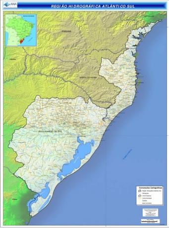
THE South Atlantic Hydrographic Basin corresponds to one of the 12 hydrographic regions of Brazil.
It is composed of several sub-basins of which the following stand out: Guaíba Basin, Jacuí Basin, Gravataí Basin, Taquari-Antas Basin, Itajaí-Açu, Tijucas Basin, Vacacaí Basin, Sinos River Basin, Pardo River Basin, Caí River Basin, Piratini River Basin and Rio Basin Jaguarão.
Characteristics and Importance

With a total area of approximately 186,000 Km² (about 2% of the national territory) the South Atlantic Hydrographic Basin is located in large areas. part in the southern region of the country covering the states of Paraná (3.1%), Santa Catarina (19.7%), Rio Grande do Sul (76.4%) and a small portion of São Paulo (0.8 %).
The South Atlantic Hydrographic Basin has great socioeconomic importance for the region, being one of the most developed regions of the country with about 12 million inhabitants (almost 7% of the country's population), which covers about 450 municipalities.
The predominant climate in the region is the Temperate climate Rainy and the present Biomes are the Atlantic forest, Araucaria Forest and Mangrove swamps, which are being explored and suffering a great environmental impact, such as river pollution. Tourism, agriculture and mining are the most prominent economic activities.
Read about the Hydrography of Brazil.
rivers
The main rivers that make up the South Atlantic Hydrographic Basin are:
- Itajaí River
- Rio Acu
- Capivari river
- Jacuí River
- Vacacai River
- Piratini River
- Jaguarão River
- Taquari River
- Itapocú River
- Tijucas River
- Antas River
- Camaquã River
- Guaíba River
- river bells
- Rio Pardo
- River Cai
know more about Hydrographic basin.


