Morphoclimatic domain is a geographic classification that encompasses natural aspects such as climate, hydrography, vegetation, relief and soil, predominant in a given area, and the way they become relate to each other.
Brazilian morphoclimatic domains there are six: amazon, caatinga, sea of hills, cerrado, araucarias and prairies.
The 6 morphoclimatic domains of Brazil explained
Check out the information below and see everything you need to know about each of the Brazilian morphoclimatic domains.
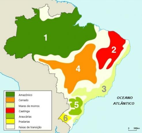
1. Amazonian morphoclimatic domain

The Amazonian morphoclimatic domain is the largest in Brazil, and is practically all located in the North region of the country.
Relief of the Amazonian domain
With regard to relief, it is a domain whose composition is mostly in lowlands, that is, in places of low latitudes and large depressions.
Amazonian domain climate
The climate is equatorial, hot and humid and rains usually occur throughout the year.
The average temperature usually reaches between 24ºC and 27ºC.
Amazonian domain hydrography
Hydrography is one of the highlights of this domain, as the largest hydrographic basin in Brazil, the Amazon hydrographic basin. This influences the fact that the region has a large volume of water.
Amazonian domain soil
The vast majority of the soil in the Amazon region is composed of latosols (made up largely of mineral material) and argisols (they show a very clear separation from horizons of color).
As a general rule, the soil in the Amazon region does not have a high fertility rate.
Vegetation in the Amazon domain
The vegetation is very diverse and perennial, that is, it does not usually lose leaves throughout the year. The vegetal aspect varies according to the proximity of the water courses and is subdivided into three types:
- Igapó forests: present in areas constantly flooded by rivers.
- Flooded Forest: present in areas that are occasionally flooded by rivers.
- Upland forests: present in areas that are not flooded by rivers.
2. Morphoclimatic domain of the caatinga
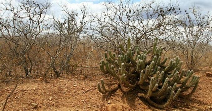
Relief of the caatinga domain
The morphoclimatic domain of the caatinga is located in the Northeast region of Brazil, and presents a relief formed by depressions.
Climate of the caatinga domain
The semi-arid climate contributes to low rainfall in the area. The caatinga goes through drought periods of more than one year and suffers from several droughts.
Hydrography of the caatinga domain
As far as hydrography is concerned, most rivers are temporary (dry once a year).
This is due to the high temperatures in the region and also due to the type of soil, which, as it does not have good permeability, contributes to water evaporation.
Caatinga domain soil
Poor soil permeability has a direct impact on the amount of nutrients; the more water you can hold, the more nourished and fertile a soil is. Clay soils (which contain clay in 30% of their composition), for example, have more nutrients than sandy soils (which contain sand in 70% of their composition).
As a general rule, the caatinga has shallow soil, that is, a soil whose rock layer is very close to the surface.
Vegetation in the caatinga domain
The fact that the caatinga has a shallow soil makes it difficult for plant roots to explore the soil in depth.
The vegetation of the caatinga is subdivided into three types:
- Arboreal: vegetation that is 8 to 12 meters long.
- Shrub: vegetation that has 2 to 5 meters.
- Herbaceous: vegetation that is below 2 meters.
A very characteristic fact of the caatinga vegetation is that it managed to adapt to local conditions. Carnauba, for example, produces a kind of wax that coats its leaves and helps prevent water loss through evaporation. Juazeiro, in turn, developed extremely deep roots, which allow the absorption of water from the soil. There are plants that have the ability to retain water; some cactus species, for example, can hold more than 3 liters.
To learn more about the caatinga, see also: Caatinga climate.
3. Morphoclimatic domain of the seas of hills
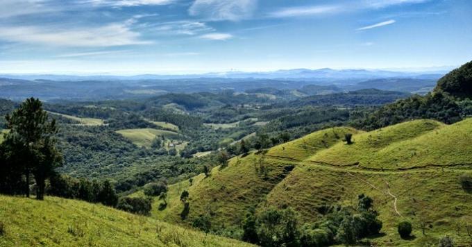
The domain of the seas of hills occupies the Brazilian coast, extending from the Northeast to the South of the country.
Relief of the domain of the seas of hills
The relief of the region, which gave rise to the designation of this morphoclimatic domain, is characterized by the presence of rounded hills, plateaus and mountain ranges, among which the Serra do Mar stands out.
Climate of the domain of the seas of hills
Although the climate of the seas of hills can vary according to the regions, the humid tropical climate is predominant.
Due to the tropical climate of high temperatures, the rainfall index is high. This can make the slopes not so safe; the risk of landslides is constant.
Hydrography of the domain of the seas of hills
With regard to hydrography, this morphoclimatic domain presents a vast volume of water. It covers two important Brazilian hydrographic basins: the Paraná River hydrographic basin and the São Francisco River hydrographic basin. In addition, it also has important hydroelectric plants: those on the Paraná River, São Simão and Três Marias.
Despite the abundance of water, a large part of the rivers in the sea of hills present serious problems related to pollution and contamination.
Soil of the domain of the seas of hills
Regarding the type of soil, one of the predominant ones in this domain is the massapé. It is formed by the decomposition of granite and gneiss in the northeastern forest. Another prominent soil is salmon, which is formed by the destruction and chemical decomposition of granite in the Southeast region. Due to good irrigation, the soil of the sea of hills is very fertile.
Vegetation of the domain of the seas of hills
The vegetation of the seas of hills is one of the most damaged in terms of preservation. The expansion of commercial agriculture, deforestation for logging and the development of urban centers are some of the factors that contribute to this scenario.
In the region, the typical vegetation is that of the Atlantic Forest, also called Humid Tropical Forest, which due to the environmental devastation is represented by only 7% of its original extent (usually in difficult places access).
To learn more about seas of hills, see also: hill seas
4. Morphoclimatic domain of the cerrado
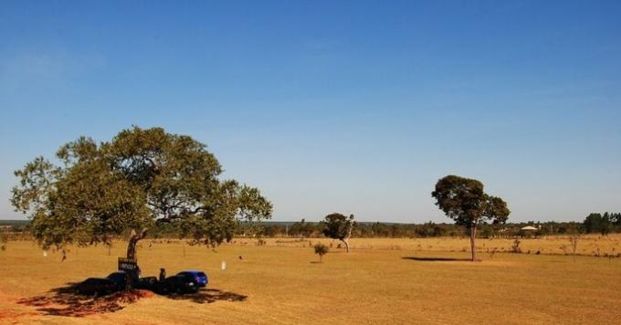
Cerrado domain relief
In the cerrado domain, the relief is mostly flat or with small undulations. Composed of large plateaus and plateaus, this morphoclimatic domain has about 50% of its altitude between 300 and 600 meters.
Climate of the cerrado domain
The climate that prevails in the cerrado is seasonal tropical. The average temperature in the region is around 22 degrees Celsius. However, the high can exceed 40 and the low can go below 0, resulting in frost.
This is an area where the seasons are quite defined: it rains a lot in the summer and the winter is dry.
The place also usually goes through a severe period of drought from October to April.
Cerrado domain hydrography
Located in the central region of the country, the cerrado is also called "Brazil's water tank" because of its hydrography. In its territory are located river beds and sources of 8 of the 12 Brazilian hydrographic basins. Examples of these rivers are the Rio Araguaia, the Rio Tocantins and the Rio São Francisco.
Cerrado hydrography is responsible for the generation of energy in 9 out of 10 Brazilians, due to the importance of this morphoclimatic domain for the country's hydroelectric resources.
Cerrado domain soil
The cerrado soil is typically reddish and can be sandy or clayey.
The predominant soil types in this domain are:
- Oxisol: reddish/yellowish in color, it is a type of soil poor in nutrients, which covers about 46% of the cerrado domain. It's deep soil.
- Podzolic: fertile mineral soil with a dark reddish color and considerable iron content. This type of soil is very susceptible to erosion.
Vegetation in the Cerrado domain
The vegetation of the cerrado consists mainly of shrubs and low trees, which are not usually concentrated in groups, but rather apart from each other. Typically, the trunks have a very thick bark and a gnarled appearance; leaves are often rough.
Environmental impacts in the cerrado domain
The cerrado is the morphoclimatic domain that has been most damaged by environmental impacts over the years. Among the main causes of this degradation are:
- Contamination of rivers.
- Opening of highways.
- Expansion of agricultural frontiers.
- Burns.
5. Morphoclimatic domain of araucarias
Relief of the domain of araucarias
The relief of the Araucaria domain is characterized by strong undulations and mountainous terrain. With a protruding appearance and formed by the process of erosion, this domain is located on the southern plateau, and has an altitude ranging from 500 to 1,300 meters.
Part of the relief of araucarias is formed by the action of erosion on rocks of different strength.
Climate of the Araucaria domain
The climate is mostly subtropical and has average temperatures, which usually vary between 14 and 30 degrees.
The seasons are defined and, therefore, winters are usually harsh and summers are hot. The distribution of rainfall throughout the year is usually quite uniform.
Hydrography of the Araucaria domain
With regard to hydrography, the domain of araucarias has great potential, as it encompasses some of the main hydroelectric plants in the country. Among them are the Itaipu Plant and the Furnas Plant.
Drainage takes place mainly through the rivers of the Paraná Basin and the Uruguay Basin. Twice a year, many of the rivers in this domain cross two periods of flood and two periods of low water levels.
Soil of the Araucaria domain
The most characteristic soil type of araucarias is terra roxa. Despite the name, it is a reddish colored soil, which has a volcanic origin and is formed through the decomposition of basalt.
This soil has constant moisture, which occurs because the araucaria rivers never dry out. This makes the purple soil naturally fertile and suitable for planting.
Vegetation in the Araucaria domain
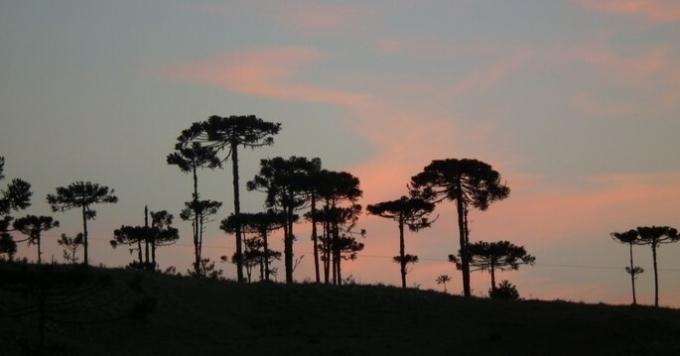
The predominant vegetation is the Araucaria Forest, also called Mata dos Pinhais, which consists of a low density forest.
In Brazil, it concentrates the only example of conifers (a species whose fruit is cone-shaped).
The original forest stretched from São Paulo to Rio Grande do Sul, occupying an area of about 200 thousand km2. Due to exploration for the production of furniture and paper, vegetation was significantly reduced.
6. Morphoclimatic domain of the prairies
Relief of the domain of the prairies
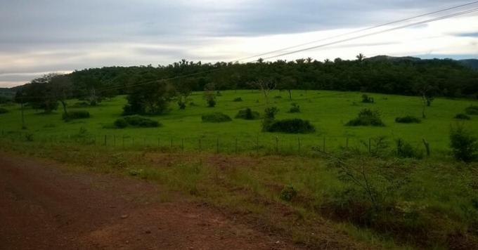
Also called Pampas or Campanha Gaúcha, the morphoclimatic domain of the prairies presents low relief and slight undulations called hillocks.
Due to the breadth of this type of relief, the region is used for the practice of livestock.
Climate of the Prairie Domain
Taking into account the climate, prairies can be divided into two different types:
- Temperate prairies: are those whose climate varies between hot and cold temperatures, according to the seasons. Summer and spring usually have a large volume of rain; winter and autumn are typically dry.
- Tropical prairies: are those that have a hot and dry climate throughout the year.
Prairie Domain Hydrography
With regard to hydrography, some rivers stand out, such as the Ibicuí River, the Santa Maria River and the Uruguay River. These rivers present great flow, and are responsible for the uninterrupted drainage of this morphoclimatic domain. They all belong to the Uruguay Basin.
Soil from the domain of the prairies
Prairie soil is usually deep and dark in color. The color tone comes from the decomposition of an organic matter that covers it, called humus.
The humus makes the soil fertile and, because of that, the prairies are usually used for planting, mainly cereals.
In some prairie regions, the soil type is sandstone. In these places, agriculture is developed through the use of machines and soil correction techniques.
Two other types of soil found in the prairies are the red paleosol and the light paleosol.
Vegetation of the Prairie Domain
With regard to vegetation, the grasslands are covered by herbaceous and creeping species, with heights that usually vary between 10 and 50 cm.
To learn more about the prairies, see also: prairies.
Transition bands of morphoclimatic domains
The transition bands are areas located between the morphoclimatic domains, which delimit them and present specific characteristics.
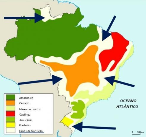
Such features are usually a mixture of aspects of domains whose boundaries are delimited by bands.
Environmental impacts on morphoclimatic domains in Brazil
Over the years, the six Brazilian morphoclimatic domains suffered impacts that modified their original characteristics.
Forests that were once vast and dense, such as the Araucárias, today practically no longer exist, some rivers have been contaminated with the mercury used by miners, the practice of agriculture without prior soil preparation resulted in erosion, among others.
These environmental changes were the result of human action. See some aspects that contributed to the devastation:
- Wood extraction.
- Unsustainable agricultural activity.
- Expansion of cities.
- Release of sewage into the sea.
What is the difference between morphoclimatic domains and biomes?
The word biome considers a set of living beings (fauna and flora) that live adapted to the conditions of a particular region, and the way they interact with that environment. A biome can be said to be a biological community; a set of ecosystems.
A morphoclimatic domain, in turn, considers the combination of a series of natural elements such as relief, climate, vegetation, soil and hydrography, and the way in which these elements interact with each other.
Thus, we can say that, while the biome emphasizes life (types of species and ecosystems), the morphoclimatic domain highlights the aspects physical characteristics, especially with regard to the way in which climate, vegetation, relief, soil and hydrography interact, and the resulting landscape. interaction.
Exercises on morphoclimatic domains
1. (FURB/2018) Geographer Aziz Ab’Sáber created a domain-based classification model of Brazil's natural landscape. These domains are classified according to the similarities of relief, climate, vegetation, soil and hydrography of a given region. It is considered a complete model, as it takes into account several geographic elements, composing the natural framework of a region. In Brazil, there are six morphoclimatic domains: Amazon, Araucaria, Caatingas, Cerrado, Mares de Morros and Prairias, in addition to the Transition Strips. Regarding the characteristics of Brazilian morphoclimatic domains, it is correct to state that:
a) The morphoclimatic domain of the Mares de Morros has a striking feature that even baptizes it. This is the morphology of its relief, predominantly represented by the compartment called Plateaus and Mountains of the East-Southeast Atlantic.
b) The conservation of the Prairies is fundamental, as it presents a diversity of formations. vegetation that includes shrub, arboreal and herbaceous strata, with paths and important forests ciliary
c) Despite having a wide area, the Araucaria domain does not extend much in the latitudinal sense, being almost all located in a region close to the Equator Line. As a result, insolation is strong all year round and the active air masses are hot and humid.
d) The Amazon region has two very well defined climates throughout the year, one very dry and cold (but with a large temperature range throughout the day) and the other humid and hot.
e) In hydrographic terms, the Caatinga region stands out for sheltering springs and water courses that supply some of the main rivers in South America, involving the Tocantins-Araguaia basin and parts of the São Francisco and the Paraná.
Correct alternative: a) The morphoclimatic domain of the Seas of Morros has a striking feature that even baptizes it. This is the morphology of its relief, predominantly represented by the compartment called Plateaus and Mountains of the East-Southeast Atlantic.
a) CORRECT: The relief of the region, which gave rise to the designation of this morphoclimatic domain, is characterized by the presence of rounded hills, plateaus and mountain ranges.
b) WRONG. The grasslands are covered with herbaceous and underbrush, whose height usually varies between 10 and 50 cm. Thus, it does not cover shrub and arboreal strata. The paths and riparian forests are not typical of the prairies either.
c) WRONG. The equator line crosses the northern region of Brazil. The domain of araucarias occupies part of the Southeast and South regions.
d) WRONG. The climate of the Amazon domain is equatorial, and therefore hot and humid
e) WRONG. The Tocantins-Araguaia Basin and the São Francisco Basin are part of the Cerrado domain. The Paraná hydrographic basin is part of the Mares de Morros domain.
2. (Fundatec/2018) Among the morphoclimatic domains in Brazil, which has been most impacted in recent decades due to the expansion of economic activities in the region?
a) Caatinga.
b) Cerrado.
c) Pampa.
d) Prairie.
e) Araucaria Forest.
Correct alternative: b) Cerrado.
Although all morphoclimatic domains have suffered environmental impacts over the years, in general, the cerrado was the hardest hit.
The most serious damage was caused in the rivers, as a result of the mining: the waters were contaminated with mercury.
The creation of highways and the construction of the city of Brasília were two factors that greatly contributed to the environmental degradation of the cerrado.
One of the main causes of the great environmental impact suffered by the cerrado was the expansion of agricultural frontiers. Some soils in the cerrado, which were naturally not suitable for agriculture, were corrected with advanced cultivation techniques. It must be recognized that this approach has brought greater agricultural productivity. However, it was not an orderly expansion and, with that, many places where there were large need for preservation (such as forests located on the banks of rivers, lakes and lakes) were disrespected.
The carrying out of fires to remove forests in places where one wanted to practice agriculture and cattle raising contributed a lot to the deforestation of the cerrado domain.
3. (SEDUC-PI/2015) For the analysis of Brazilian natural landscapes, the geographer Ab’Saber (1967) proposed a classification in morphoclimatic domains.
Check the alternative that CORRECTLY presents the aspects related to the conception of the reading of landscapes by Ab.Saber.
a) It expresses the intrinsic relationship between phytogeographic conditions, climatic fluctuations and the forms of land surface modeling.
b) The geographic delimitations of the Brazilian morphoclimatic domains are precise, based on the specific conditions of each one, without transition areas or interconnection between them.
c) The Brazilian morphoclimatic domains are proposed considering the geological and geomorphological aspects of the hydrographic basins.
d) Uses endemism as a criterion for classification as that which occurs in the Cerrado and Caatinga, Brazilian morphoclimatic domains exclusive to the Northeast Region.
e) Considers the aspects inherent in the classification of macro-compartments of the Brazilian relief as plains, plateaus and depressions.
Correct alternative: a) Expresses the intrinsic relationship between phytogeographic conditions, climatic fluctuations and the shapes of the land surface modelling.
a) CORRECT. Morphoclimatic domain is a geographic classification that encompasses natural aspects such as climate, hydrography, vegetation, relief and soil, predominant in a given area, and the way they become relate to each other.
b) WRONG. Among the morphoclimatic domains, there are areas called “transition bands”. These areas have characteristics that are usually a mixture of aspects of the domains whose boundaries are delimited by them.
c) WRONG. Aspects related to the conception of landscape reading by Ab daSaber do not only consider aspects of watersheds, but aspects of relief, climate, soil, vegetation and hydrography as a whole.
d) WRONG. The domain of the cerrado is located in the central region of Brazil, not in the Northeast region.
e) WRONG. The aspects related to the conception of the reading of landscapes by Ab nãoSaber do not only consider aspects of relief, but also of climate, soil, vegetation and hydrography.
See too: Exercises on Climates in Brazil

