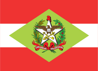
The State of Santa Catarina is located in the southern region of Brazil. The capital is Florianópolis and the acronym SC.
- Area: 95,737,895
- Limits: to the south with Rio Grande do Sul, to the east with the Atlantic Ocean, to the north with Paraná and to the west with Argentina
- Number of municipalities: 295
- Population: 6.8 million inhabitants, according to the IBGE estimate for 2015
- Gentile: those born in Santa Catarina are from Santa Catarina
- Main city: Florianópolis
 Flag of the State of Santa Catarina
History
The State of Santa Catarina is strongly influenced by Spanish, German, Italian and Portuguese Azoreans.
The city of Florianópolis was founded in 1777. The island was handed over to the Portuguese at the signing of the Treaty of Santo Ildefonso.
It was only in 1738 that the island was colonized by the Azorean Portuguese. The Portuguese influence is observed in the economy, architecture and in the way of speaking of Florianopolitano.
The island has 43 beaches, Jurerê and Joaquina being the most famous.
Read too:
- Federalist Revolution
- Contested War
- South region
- southern states
- Brazil states
- Acronyms of Brazilian States
Joinville
The largest city in Santa Catarina is also the largest industrial hub in the state. The region is the portrait of German colonization in Brazil. The influence is observed in food, customs and, above all, in architecture.
The territory now occupied by Joinville was donated to the prince of Joinville, who married Dom Pedro II's sister, Dona Francisca.
In addition to Germans, the region attracted immigrants from Switzerland and Norway.
Geographical Aspects
Most of Santa Catarina's territory is occupied by the Sandstone-Basalt Plateau, which makes up the Brazilian Meridional Plateau.
The climate is subtropical, with temperatures below 18ºC.
The main rivers in the state are Canoas and Pelotas. The Iguaçu and Tubarão rivers are also significant.
Keep studying!
- Southern Economy
- South Region Climate
- South Region Culture
- Uruguay Basin


