Cartography is the science that graphically represents a geographic area or a flat surface.. It is the study that operates in the design, production, dissemination, representation and the entire process of maps. This is the definition of the International Cartographic Association.
Cartography is a complex field in constant change and in the broadest sense it includes everything from collection to evaluation and processing of source data through data collection, evaluation, processing, graphic design of the map and drawing Final.
In addition to physical representation, cartography is used to illustrate social, economic, historical and cultural reality.
The study of maps is sometimes translated as a unique blend of science, art and technology that involves more than one individual. Cartography involves, in addition to elaboration, scientific investigation, involving mathematics, history and technology.
In the current model of civilization, cartography plays an important role in understanding social and geographic phenomena. It is involved in land use, weather forecasting, forest management and even road construction.
Knowledge about mineral wealth, emergency response and even navigation depend on cartographic studies.
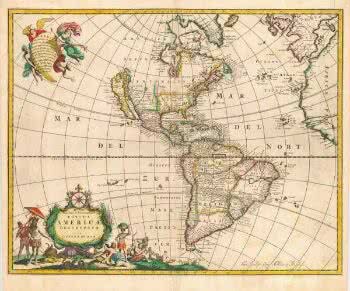 Map of South America by Johannes de Ram
Among the characteristics of cartography is dynamism. Previously dependent on manual equipment, even pens and paper, today the work is done with the most modern graphic software. The computer, as in most fields, endowed cartography with greater precision and reliability.
History of Cartography
Cartography was already used in prehistory to represent territories suitable for hunting and fishing. In Babylon, science demonstrated the flat, disc-shaped world.
It was, however, Ptolemy who established sketches in eight volumes to show the spherical shape of the Earth. And Ptolemy's models were used in the Middle Ages to demonstrate the distribution of continents European, Asian and African, which were separated by a "T", formed by the Mediterranean Sea and the River Nile.
It was the discovery of the New World, on the occasion of Great Navigations, which imposed the search for new cartographic techniques and the systematic representation of the surface. Among the factors that most contributed to cartography is the use of the telescope, which allows the determination of latitude and longitude with greater precision.
Today, in addition to the telescope, software uses photographs to carry out the mapping with greater detail and precision.
Geographical coordinates
Geographic coordinates are used to locate a particular point on the earth's surface. For this, measurements indicating latitude and longitude are used. Both indicate the measure in relation to the equator line and to Greenwich Mean Time.
The measure is represented in degrees. Latitude represents parallels from the equator at latitude 0° to any point towards the Northern Hemisphere (N) or Southern Hemisphere (S). The range is from 0º to 90º. When the direction is to the Northern Hemisphere and when to the Southern Hemisphere, negative.
Longitude, on the other hand, is used to represent the meridians, starting from Greenwich to any point on the Earth's surface in the East (E) or West (W) direction. The longitude ranges from 0º to 180º. When part of the eastern hemisphere is positive and negative when part of the western hemisphere.
Read more in the articles:
- Cartographic scale exercises
- Cartographic scale
- Geographical coordinates
- Cartographic Projections
- Brazil's map
- Cartographic Scale