If the world is round - or geoid, rather – how can it be drawn on a paper or flat board? Is it possible to do this without leaving any kind of distortion, that is, without modifying anything in relation to the real world?
The answer is no. Therefore, when we place maps on a world scale, there will inevitably be “errors” or modifications purposefully made to not leave the maps so distorted or harm the use they were put to. intended. Therefore, we say that there are different cartographic projections.
Concept:cartographic projections are, therefore, the systematic trace of lines referring to the terrestrial globe on a flat surface. It is a way of representing the planet – or a part of it – on a map.
As it is impossible not to have distortions in the projections, cartographers developed different models over time, each one for a purpose. So, instead of trying to consider which is the “right” or the “wrong” projection, we need to look at its characteristics to know which one is more suitable for different purposes.
If we take into account how the projections change geographic space, we can divide them into:
Conforming projections: are those that alter the areas of the continents (that is, their size) and keep their angles and shapes preserved.
Equivalent projections: they alter the shape of the continents, making them different. On the other hand, their size remains the same compared to the original.
aphylactic projections: they change both the shape and the areas, but in such a way that these distortions are not so pronounced.
Considering the way the projections are prepared, that is, the methods used and the results produced, there are three main types of cartographic projections: a cylindrical, a conical and the flat(also called polar or azimuthal).
Cylindrical Projections: are projected from a cylinder surrounding the terrestrial sphere, so that the parallels and meridians are reproduced in the plane after the opening of that cylinder. The best known example of a cylindrical projection is the Mercator projection, which changes the area of continents and maintains their shapes.

Mercator projection, example of cylindrical projection
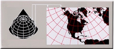
Conical Projections:they are made when a cone surrounds the terrestrial sphere and reproduces its surface. Meridians form straight lines that start from a single point in common, while parallels form semicircles, as we can see below.

Lambert projection, one of the best known types of conic projection
flat projections: also called azimuths or polar, are made with a flat circle placed on a “face” of the Earth, usually the poles. The meridians are also straight and the parallels form concentric circles. Watch:

Plane projection drawn from the pole. The UN uses a similar model in its logo
From these models, several types of cartographic projections were elaborated. As we've already said, Mercator's is the best known, being more useful for navigation purposes as it maintains the proportion of ocean areas.
The projection of Peters (image below) changes the shape of the continents and maintains their areas, being widely used to represent the importance of countries in the southern hemisphere. It is also a type of cylindrical projection.

In Peters' projection, the continents are different, but their areas are maintained
the one of robinson, which alters shape as well as areas, is widely used for political maps, as it maintains a ratio of proportion, although the areas further west and east on the map are very different.

Robinson's projection is one of the most used
By Me. Rodolfo Alves Pena
Take the opportunity to check out our video classes on the subject:


