Hydrographic basin, also called drainage basin, is a portion of the earth's surface drained by a main river, streams, streams, etc. This set of water resources is of fundamental importance to the population, providing water for consumption and for carrying out economic activities.
The Brazilian territory is home to 12 hydrographic regions, according to the National Water Resources Council (CNRH). One of them is the Eastern Northeast Atlantic Basin, which covers portions of the territories of Piauí, Ceará, Rio Grande do Norte, Paraíba, Pernambuco and Alagoas.
This basin has an extension of 287.3 thousand square kilometers, equivalent to 3% of the total area of Brazil. Among the rivers that make up the Eastern Northeast Atlantic Basin we can highlight the Açu, Acaraú, Apodi, Capibaribe, Jaguaribe, Mamanguape, Uma, etc.
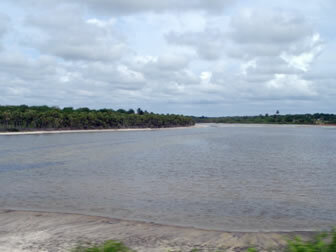
Jaguaribe River - Ceará
These rivers provide water for large capitals in the Brazilian Northeast: Recife, Fortaleza, Maceió, Natal and João Pessoa, as well as cities with high population concentration, such as Campina Grande and Caruaru. About 21.6 million people use these waters.
The vegetation along the basin is quite diversified, with areas of Atlantic forest, caatinga, cerrado, mangroves and coastal vegetation. However, the intense deforestation process caused a drastic reduction in these biomes.
By Wagner de Cerqueira and Francisco
Graduated in Geography
Kids School Team