
watershed is a portion of the earth's surface drained and bathed by a main river, streams, streams, etc. Brazil is privileged in relation to the hydrographic network, as the country is home to several rivers.
According to National Water Resources Council (CNRH), agency responsible for planning and rational use of water, the Brazilian territory has 12 large hydrographic basins.
One of these 12 basins is the Atlântico Nordeste Ocidental, which occupies an area of 254.1 thousand square kilometers. This hydrographic region is present in the western portion of Maranhão and in the extreme east of Pará.
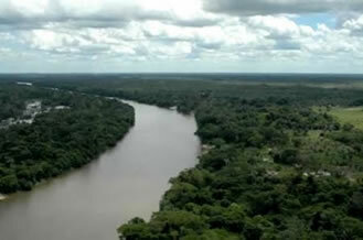
Gurupi River – Maranhão
Among the main rivers are the Mearim, Turiaçu, Pindaré, Pericumã, Grajaú, Gurupi, Itapecuru, Munim, among others. The average flow of the Western Northeast Atlantic basin is 2,514 m³/s, accounting for 1.6% of the country's total.
The waters of this basin are of fundamental importance for these states, being used in agricultural activities, livestock and for human consumption, serving around 5.3 million people.
By Wagner de Cerqueira and Francisco
Graduated in Geography
Kids School Team