Country of Oceania formed by hundreds of islands of volcanic origin in the Pacific Ocean, more precisely in the region called Melanesia, Solomon Islands it has no land borders, being relatively close to the Papua New Guinea and Vanuatu. The national capital is the city of Honiara.
The country is home to around 535.7 thousand inhabitants, with the majority residing in rural areas (81.5%). Part of the population faces socioeconomic problems, directly reflecting on the Human Development Index (HDI) of the Solomon Islands, which, according to data released in 2010 by the United Nations (UN), is 0.494, considered average.
The main economic activity is agriculture, above all subsistence, responsible for employing more than half of the local inhabitants. Among the crops are rice, cocoa and coconut. The industrial sector, which is not very diversified, is based on the food and wood segments. Despite the beautiful natural landscapes, tourism is little explored.

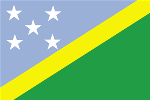
Flag of the Solomon Islands
Do not stop now... There's more after the advertising ;)
Solomon Islands Data:
Territorial extension: 28,896 km².
Location: Oceania.
Capital: Honiara.
Climate: Equatorial.
Government: Parliamentary monarchy.
Administrative division: 4 districts subdivided into government councils.
Language: English (official).
Religions: Christianity 95.3% (Protestants 38.2%, Anglicans 32.3%, Catholics 19.3%, others 5.5%), others 4.4%, atheism 0.3%.
Population: 535,699 inhabitants. (Men: 277,313; Women: 258,386).
Demographic density: 18.5 inhab./km².
Average annual population growth rate: 2.4%.
Population residing in urban areas: 18.5%.
Population residing in rural areas: 81.5%.
Life expectancy at birth: 67 years.
Infant mortality rate: 40 for every thousand live births.
Human Development Index (HDI): 0.494 (average).
Currency: Solomon Islands Dollar.
Gross Domestic Product (GDP): $658 million.
GDP per capita: $1,366.
External relations: World Bank, British Commonwealth, IMF, WTO, UN.
By Wagner de Cerqueira and Francisco
Graduated in Geography
Brazil School Team
countries - geography - Brazil School
Would you like to reference this text in a school or academic work? Look:
FRANCISCO, Wagner de Cerqueira and. "Solomon Islands"; Brazil School. Available in: https://brasilescola.uol.com.br/geografia/ilhas-salomao.htm. Accessed on June 28, 2021.


