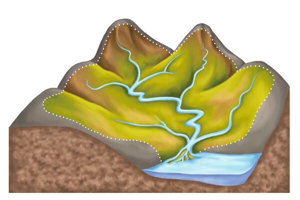
At basinshydrographic they can be defined as a part of the relief supplied by a main river, its tributaries and subfluxes. The latter are small rivers that flow into rivers intermediaries (tributaries), which flow into the main river.
Generally, the main river is the largest river that exists in this portion of the relief, and it is it that gives the name to the hydrographic basin. The rivers that flow into it make up all the rest of the regional hydrography.
To distinguish one basin from another, we use the highest parts of the relief, which we call the water dividers, as it is in these areas that water is separated from one basin to another.
Read too: Plateaus - irregular reliefs usually at high altitudes
Elements of a watershed
Among the elements that make up a watershed, there is no one that is more or less important than the other. After all, it is a set of rivers, and all have their due importance for the development of the basin.
Now let's see what these elements are.
- main river: largest river located in the delimited region of the relief. This river gives its name to the basin, being the most important, as it is the most used, whether for transport, agriculture or energy generation.
- affluent: intermediate river that feeds the main one. Large hydrographic basins have several tributaries, both on the left and right sides of the main river.
- Subafluent: river with a small flow that flows into the tributary of the main river in the basin. These small rivers are important, as they feed the entire system, being, in many cases, the source of the basin.
- water divider: area where the hydrographic basins are delimited, located in the highest area of the relief. In this part, there is the separation of waters, flowing to one side and the other.
- floodplain: when the rivers are full, this water overflows to the low banks that accompany them. The area that supports the overflowing waters is called the floodplain.
- Mouth: place where a river flows into another area with water, which could be another river, lake, pond or the sea.
Types of river basins
There are river basins that are different from each other. Understanding this difference is fundamental for us to understand how the river, with its basin, is used by the societies that surround it.
In addition, it is good to distinguish the regimes of these rivers, how they are fed and how they vary. There are rivers with a pluvial regime, when their flow depends on rainwater; rivers with a nival regime, when the origin of water occurs with the thaw; and mixed regime rivers, which depend on melting and rain. An example of the latter is the Amazon River.
Let's understand the main types of river basins:
- Endorheic: basin that flows into a lake or a closed sea, not reaching the sea open.
- exorreic: basin with water taken directly into the open sea.
- arrhea: consists of waters that disappear during the course and do not follow a specific direction. This disappearance can occur by infiltration into the soil or evaporation, as in areas of desert climate.
- Cryptorrhea: basin with waters that feed underground areas, such as caves and grottos.
We can compare the main rivers to the big ones. tributary and subafluent water deposits. The last two act from upstream (area where the Water of a river, close to the source, in the highest part), going downstream (when the waters flow towards the mouth, in the lower part).
How important is a river basin?
Since the beginning of humanity, most great civilizations arose near rivers. This happened at Mesopotamia, with the Tigris and Euphrates rivers, with the egyptian society, with the Nile River, among others. This shows us the importance of preserving this essential resource for the existence of our life.
We know that the water is a renewable resource reset to the Earth's surface daily, thanks to the hydrological cycle. However, irrational consumption, with waste, river pollution and lack of basic sanitation in many parts of the world make many people suffer from the scarcity of this resource, which a large part of the population thinks is infinite, but it is not.
O logging, soil compaction and the waterproofing of cities, with asphalt and concrete, make it difficult to infiltration of water into the soil, which compromises the volume of water following the reasoning of the cycle hydrological. In addition, springs are occupied irregularly, in addition to domestic pollution released into rivers, such as garbage and sewage.
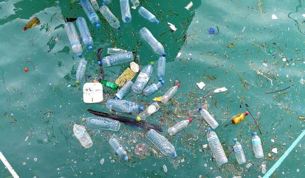
When we analyze the human attitudes, we realize that we take little care of the water that is ours. This is a big mistake, as water is the essential element for the existence of life. It is estimated that only 2.5% of the planet's water is fresh, and only 0.4% of them is suitable for consumption. The rest is in glaciers or underground, in water deposits known as aquifers.
Total water (fresh and salt) |¹|

Drinking water (fresh)

Some regions of the planet, such as the Middle East and some African countries, already suffer from situations of scarcity of water, having to import basic food, as agriculture in the region cannot be stocked.
More pessimistic studies indicate that water will be the object to be disputed in wars in the coming years, if we are not aware of its importance and if we take due care. This means that the lack of water in a region will affect everyone, directly or indirectly. It is up to all of us to preserve this essential resource.
See too: Environmental impacts caused by mining
Brazil's hydrographic basins
Brazil is known for its large territorial extension and for concentrating the Largest amount of fresh water available in the world. Approximately 12% of the planet's fresh water is in our country, a privilege.
However, such responsibility requires planning and public policies that take care of springs, such as basic sanitation, and that these resources are managed efficiently.
Due to this large amount available to Brazilians, we have several hydrographic basins in our territory. Some feed other countries in South America, while others are genuinely Brazilian, located only in our territory. Let's look at the Brazilian basins:
- Amazon Basin: it is considered the largest basin in the world and bathes six other countries in South America. Its main river, the Amazon, is widely used for transporting people and cargo, serving as a means for river navigation. In addition, it is considered the largest river in the world, with a large flow, passing through a relatively flat and shallow area. Due to this large amount of water, the Amazon basin has great hydroelectric potential, but its production is small, as there is a great distance between it and the urban and industrial centers of the parents.
- Tocantins-Araguaia Basin: a genuinely Brazilian basin, in which its two main rivers, the Araguaia (main tributary) and the Tocantins (main river), bathe 9% of the Brazilian territory. They flow from the central plateau towards the North of the country, passing through the states of Goiás, Tocantins, Mato Grosso, Pará, Maranhão and the Federal District.
- São Francisco Basin: another basin located in Brazilian territory, it covers approximately 8% of the country. The main river, San Francisco, spans a distance of 2700 km, starting in Minas Gerais and heading towards the Northeast, in the states of Bahia, Pernambuco, Sergipe and Alagoas, also bathing Goiás and the Federal District. Another important characteristic feature of this basin is the presence of three types of vegetation: thick, Caatinga and Atlantic forest.
- Platinum Basin: it is the second basin in extension, being occupied by the Paraná, Paraguay and Uruguay rivers. As the name says, this basin has as its mouth the Rio de la Plata, in Uruguay, flowing into the Atlantic Ocean.
- Paraná Basin: occupies an area of plateaus, is of great importance to the Brazilian economy, as the Itaipu hydroelectric plant and the Tietê–Paraná waterway are located there. It bathes the states of Goiás, Minas Gerais, São Paulo, Mato Grosso, Mato Grosso do Sul and Paraná.
- Uruguay Basin: its main river, the Uruguay, rises from the Canoas and Pelotas rivers. It also serves as a state divider between Santa Catarina and Rio Grande do Sul, in addition to being part of the border between Argentina and Brazil.
These last three basins do not have a main river, but numerous important small and medium rivers, forming small and medium basins. If we take the concept of hydrographic basin literally, they do not fit this issue, but they were like that defined in 2003 by the National Water Resources Council for facilitating data collection and management. water.
- South–Northeast Atlantic Basin: in this basin, the rivers flow into the Atlantic, with a stretch that goes from the mouth of the Tocantins River to the mouth of the São Francisco River.
- South-East Atlantic Basin: It is formed by the rivers that bathe the states of São Paulo, Minas Gerais, Rio de Janeiro, Espírito Santo, Bahia and Sergipe, especially the Doce and Paraíba do Sul rivers.
- South-Southeast Atlantic Basins: it travels through the states of Rio Grande do Sul, Santa Catarina, Paraná and São Paulo and part of Uruguay. We can highlight the Jacuí, Taquari, Ribeira do Iguape and tributaries.
See too:States of Brazil: capitals, data, maps, list
solved exercises
Question 1) (Fuvest) Floods, degradation of springs and the quality of water in rivers are part of the problems related to water in greater São Paulo. Among the following causes, tick the one FALSE.
a) Urban waterproofing raises the average level of groundwater.
b) The Tietê, Pinheiros rivers and the Billings dam are used for the discharge of domestic sewage.
c) The Alto Tietê hydrographic basin presents relevant waterproofing.
d) There is intense urbanization in former river floodplains.
e) There is urbanization in areas included in the Watershed Protection Law.
Resolution
Alternative a.
Waterproofing in big cities prevents rainwater from seeping into the ground, which can lower the level of groundwater.
Question 2) Water is an essential resource for the existence of life on the planet. However, several regions currently suffer from scarcity of this resource, while others have great availability of it. Check the alternative that contains regions where the presence of water is low and with a risk of concern for those who inhabit them:
a) South America
b) North America
c) Middle East
d) South Asia
e) Iberian Peninsula
Resolution
Alternative c.
In the Middle East, countries like Israel, Syria, among others, already suffer from water scarcity, having to use expensive methods to acquire it, such as desalination — when removing the salt from the water of the sea. It is an expensive process that few people have access to.
Note
|1| Graphics created by the author
By Attila Matthias
Geography teacher
Source: Brazil School - https://brasilescola.uol.com.br/geografia/bacias-hidrograficas.htm