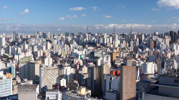
The city of Rio Branco is the capital of the state of Acre, unit belonging to North region of Brazil. Inserted in the Amazon biome, it has a relief marked by the presence of plains and a hot and humid climate. Its population of 413,000 inhabitants represents 46% of the entire state population, although it is one of the smallest Brazilian capitals. In addition to being the political center, it plays the role of Acre's economic center.
Read too: What are the state capitals of Brazil?
General data for Rio Branco
Gentile: Rio Branco
Location:
- Parents: Brazil
- Federative unit: Acre
- Intermediate region: White River
- Immediate region: White River
- Metropolitan region: there are no established metropolitan regions.
- Bordering municipalities: Sena Madureira, Bujari, Porto Acre, Senator Guiomard, Capixaba, Xapuri, Brasileia.
geography
- Total area: 8,835.154 km² (IBGE, 2020)
- Total population: 413,418 inhabitants (IBGE, 2020)
- Density: 38.03 inhab./km² (IBGE, 2010)
- Climate: wet tropical
- Altitude: 153 meters
- Timezone: GMT -5
Historic
- Foundation: December 28, 1882
Do not stop now... There's more after the advertising ;)
Geography of Rio Branco
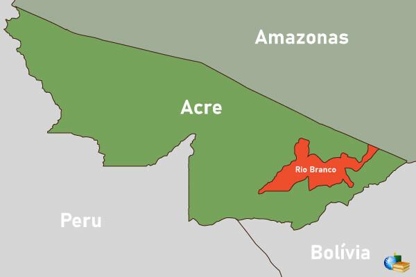
Rio Branco is a Brazilian municipality located in the North region of the country. It belongs to the state of Acre, and houses the seat of government of that state. It is therefore considered its capital. The city is located in southeast portion of the acrian territory, bordering seven other municipalities:
Sena Madureira, west and northwest
Bujari and Porto Acre, to the north
Senator Guiomard, east and southeast
Capixaba and Xapuri, to the south
Brasileia, southwest
The Acrian capital has a surface of 8,835,154 km², according to data from IBGE. It's the fifth largest municipality in territorial extension of the state, staying in 150th place in the national ranking. Rio Branco is also close to the state borders with the Amazons and with Rondônia, in addition to international borders with the Bolivian and Peruvian territories.
Rio Branco climate
Located in northwestern Brazil and inserted in the Amazon biome, it occurs in the city of Rio Branco o climate Twet tropical. This climate type is characterized by high humidity levels most of the year (above 70%) and by temperatures that remain above 18°C, even during the Winter. Under the influence of the Atlantic Polar mass, there can be colder days, although it is a very short period of time. Also, this season it is characterized by the lowest rainfall recorded throughout the year.
The average temperature in the city varies between 22 ºC and 25 ºC, while the rains accumulated in the year can add more than 2000 mm.
See too: What is the difference between weather and climate?
Relief of Rio Branco
Rio Branco is located in the domainthe dat plains and Amazon lowlands, according to the classification proposed by Aziz Ab’Sáber. Thus, the city's relief varies between gently undulating and flat, with low altimetric amplitude. The river terraces also make up the Rio Branco geomorphological framework, which is due to the presence of the Acre River, which runs through the municipality.
Vegetation of Rio Branco
Anthropic areas represent the largest portion of land cover in the Acriana capital, with few areas of remaining native vegetation. Rio Branco, however, belongs to Amazon and is characterized by the formation of equatorial and alluvial forest.
Rio Branco Hydrography
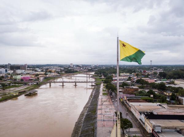
One of the main rivers in the state, theryo Acre, divides the territory of Rio Branco into two different districts, called First and Second District. During the period when there is a higher incidence of rain, certain areas of the capital are subject to flooding. The Rio Branco hydrographic network is also formed by the streams.
Rio Branco map
Rio Branco Demographics
The city of Rio Branco is the most populous in Acre, today bringing together a contingent of 413,418 inhabitants. This value is equivalent to 46.2% of the entire state population, which exceeds 894 thousand inhabitants. On a national scale, the population of Rio Branco is the 66th largest in Brazil, being the second smallest capital after Porto Velho. Its population distribution is also among the lowest in the national territory, with 38.03 inhabitants/km², but much higher than the state average of 4.47 inhabitants/km².
Data from the 2010 Demographic Census indicate that the African capital has a pretty young population, with a large concentration of people between the age groups of 10 to 14 years old and in the interval between the groups of 10 to 39 years old.
Concerning color or race:
brown (65.99%)
white (26.12%)
blacks (5.54%)
yellow (2.13%)
indigenous (0.21%)
The IBGE also breaks down by religion, in which there is a majority of the Catholic and Evangelical population, with a Spiritist minority.
Read too: Relationship between population growth and scarcity of natural resources
Geographical division of Rio Branco
The city of Rio Branco has a natural divider, which is the ryo Acre. On its left bank is the First District, while on the right bank is located the Second District. Each of them is formed by distinct urban areas that are conventionally called regional, which are numbered from I to VII. Regions II through VI are located in the First District, and regions I and VII are located in the Second District.
Finally, the urban areas of the municipality of Rio Branco are subdivided into neighborhoods, a total of 110.
Rio Branco Economy
The city of Rio Branco concentrates the main industries in the state of Acre, in addition to being responsible for approximately 58% of the state's Gross Domestic Product (GDP). According to IBGE data for 2018, the municipal GDP is in the order of R$ 8.94 billion, representing the 3rd lowest value among the capitals of Brazil. The per capita value is R$22,287, the second in Acre and the 19th among state headquarters.
O tertiary sector, which covers the activities of commerce, tourism, finance and public administration services, is responsible for the largest portion of Rio Branco's GDP. Plant extraction, with emphasis on the timber business and the extraction of rubber and Brazil nuts, is the main economic activity in Acre and also stands out in Rio Branco, together with the food, textile and transformation.
Added to the production of three other Acrian municipalities in its vicinity, Rio Branco's milk production is one of the highlights of the primary sector, as well as the aquaculture activity. Among the agricultural crops developed in Rio Branco are soy, sugar cane, rice, sweet potato, corn, beans, watermelon and pineapple, in addition to vegetables.
Government of Rio Branco
The government of Rio Branco belongs to representative democratic type. Every four years, municipal elections are held for the population to choose the occupants of the positions of Mayor, head of the local Executive Branch, and of the councilors, who make up the Legislature. The City Council of Rio Branco is composed of 17 councilors.
The municipality is also the seat of the government of the state of Acre, being, therefore, the state capital. The building that houses this function is the Rio Branco Palace, located in the city center.

Rio Branco Infrastructure
According to data available by IBGE, the capital of Acre has 92.5% of their households in their urbanized area, while 7.4% are located in the countryside. Is very the percentage of people from Rio Branco that ownsi access to the sanitation network. When the last Census was carried out, the percentage was 56.7%. In 2020, among the 100 largest cities in Brazil, Rio Branco was ranked 84th in terms of citizens' access to basic urban services.
Intraurban transport is carried out through the almost 60 bus lines that travel throughout the Acrisan capital on different itineraries. Intercity and interstate trips are mainly made through highways, such as highways 364 and 317, which also link Acre to the border countries and to the central and southern regions of Brazil, by example. It is in the children's capital o largest and main airport in the state, which is the Rio Branco International Airport.
Rio Branco Culture
The creative capital holds a wide cultural diversity formed by elements incorporated by migrants from other regions of Brazil and neighboring countries, as well as by indigenous populations. Fairs and festivals are held every year to promote the culture and traditions of these indigenous populations. Folkloric and religious celebrations They also have space in the city's cultural agenda, such as the Festas Juninas circuit, which includes the Festival de Quadrilhas Juninas and the Arraial Cultural.
The history of Rio Branco can be revisited through the monuments and historic buildings, like:
the Gameleira
the rubber museum
the New Old Market
the Rio Branco Palace
the Peoples of the Forest Square
the Rubber Tappers' Square
the House of Indigenous Peoples
a series of theaters, urban parks and green areas
Among other important historical sites, Rio Branco also houses the first geoglyph to be listed as cultural heritage by the National Historical and Artistic Heritage Institute (Iphan). It is the geoglyph of Jacob Sá archaeological site, whose listing was completed in 2018.
Read too: Cultural historical heritage - important cultural productions of a given society
History of Rio Branco
The rubber economy, which came to be called Rubber Cycleand that emerged from the last years of the 19th century, played a fundamental role in the formation process of the city of Rio Branco. This came from the Return of the Company, on December 28, 1882, thus being the oldest in the state of Acre.
Very early in this process, the Acre River became a means of travel and also access to the region, being heavily transported by vapors. Since then, there has been a gain in dynamism in the regional economy and the beginning of the centralization of primary activities, such as cattle raising and, of course, latex extraction.
With the Acrian Revolution (1889-1903), which culminated in the definitive annexation of Acre to Brazilian territory, the city was also consolidated as the political center of the state and was, until then, called Villa Rio Branco. The municipality was finally recognized as a children's capital only in the year 1920.
Two decades later, the Battle of Rubber event was highlighted as important for the arrival of new immigrants northeastern people to the capital, which brought profound structural transformations and improvements to Rio Branco, especially in the sector of urban infrastructure. The urban fabric of Rio Branco has been gaining more and more importance and relevance on a state scale, and is currently the main city in Acre and its region of influence.
By Paloma Guitarrara
Geography teacher