
O Suez Canalit's an artificial opening built in Egyptian territory to connect the Red and Mediterranean seas and allow maritime communication between the Europe and the Asia without the need to outline the African continent. This passage made Egypt a kind of gateway between West and East.
Read too: Process of creating Middle East States
Origin of the Suez Canal
The construction of the Suez Canal was idealized by the frenchFerdinand de Lesseps. The work started in 1859 and took ten years to complete, opening on November 17, 1869. Its construction was financed with British capital and used French technology. It is estimated that approximately 1.5 million workers were employed during the construction of the canal. Of these, 25,000 lost their lives in carrying out this project.
The Suez Canal has allowed sea voyages between Europe and Asia to be reduced by approximately 7,000 kilometers, since bypassing the African continent is no longer mandatory for the realization of trade between both continents.
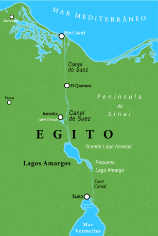
Main features of the Suez Canal
the Suez channel is located in Egypt, on the Sinai Peninsula, and connects the cities of Suez and Porto Said, passing through important cities such as Ismailia and Fayed. The Channel has 193 kilometers long, 24 meters deep and 365 meters wide. With regard to the crossing time, it varies between 11 and 18 hours.
According to the company responsible for managing the Suez Canal, in 2016, the crossing between the Mediterranean and Red seas was carried out by 16,833 vessels, transporting approximately 819,154 million tons, making it the main maritime route of the world. At the moment, 14% of world trade pass through the Suez Canal.
O Suez canal is the largest canal without locks in the world. Dispensing with locks (work that regularizes a watercourse to make it navigable), such as those required in the Panama Canal, is justified because the Red and Mediterranean seas are at the same altimetric level. The entire length of the channel encompasses three large lakes:
to the north, the Manzala;
then Timsah; and,
to the south, the Bitter lakes.
In these more than one hundred years of operation, the Suez Canal it was modified to meet the growing technological development of the naval industry, as cargo ships greatly expanded their transport capacity. For comparison purposes, in 1956, the vessels were, on average, 148 m wide on the deck (upper part of the vessel) and 36 m wide on the hull (lower part of the vessel). In 2010, these dimensions were expanded to 313 m wide on the deck and 121 m wide on the hull. Thus, the capacity to transport cargo, per vessel, jumped, in this period, from 30 thousand to 240 thousand tons.
Do not stop now... There's more after the advertising ;)
New Suez Canal
In 2015, the government of Egypt inaugurated the “New Suez Canal” with the construction of a new canal, parallel to the existing one, 35 km long. With this expansion, the Suez Canal now has 115.5 km of duplicated lane and allowed simultaneous crossings of boats in both directions. It is estimated that the channel crossing capacity will be increased from 49 to 97 vessels per day by the year 2023, when all the work is completed and in operation.
Maritime trade experts are resistant to the predictions of the Suez Canal Maritime Authority, which predicts such a robust growth in demand for crossing the canal. Two factors are used to reduce these expectations: the complex situation involving world trade (such optimistic forecasts are increasingly difficult to materialize) and also the instability of the oil market, which represents the main cost of transport maritime. Variation in prices can stimulate or reduce interest in this type of transport.
In 2016, the Suez Canal authority, seeing a loss of revenue compared to the previous year, started to grant discounts from 30% for vessels that have routes that allow a choice between using the channel and crossing the Cape of Good Hope (outline gives Africa). Although it seems pointless to opt for the longer path, this option has been widely considered due to the sharp drop in the price of oil for ships (Buker). Thus, even having to travel longer distances, the low price of fuel it becomes more attractive in relation to the high costs of crossing the Suez Canal.
See too: What is the difference between export and import?

Competition with the Panama Canal
Another concern of the Suez Canal authority is the threat that the Panama Canal, after completing its enlargement, will pose. Currently, Suez has an advantage when crossing large vessels, a fact that puts the rival at a disadvantage. THE Panama Canal enlargement will allow large cargo ships to pass through its locks and locks and, thus, make the market for crossings through the geographic isthmus of the America and from Asia even more competitive.
by Hugo Mota
Geography teacher