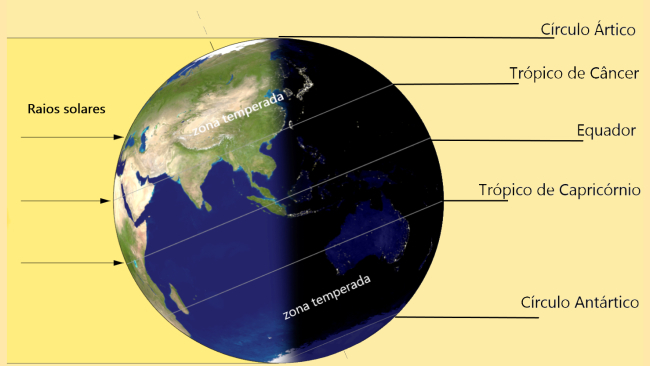
The tropics of Cancer and Capricorn are imaginary lines parallel to the equator. The band around the Earth delimited by the Tropics of Cancer and Capricorn defines the "tropical latitudes" (or simply the "tropics") where it is possible to have the sun directly overhead.
The Tropic of Cancer is an imaginary latitude line above the equator that crosses the globe at about 23 degrees north.. This is the exact spot where the sun is up on June 21st.
the opposite is the Tropic of Capricorn, whose latitude line circles the globe at about 23 degrees south (below the equator). In the Tropic of Capricorn, the sun is right at the top on December 21st.
The Tropic of Cancer and Tropic of Capricorn lines, which were named about 2,000 years ago, divide the Earth into separate zones. However, the most important line of latitude is the equator, which divides the globe in half to form the northern and southern hemispheres.

Why are the tropics important?
The tropics were marked because both are places within the hemispheres where it is possible to have the sun directly overhead.
The Earth's axis is tilted at an angle of 23.5° to the Sun. This means that during the course of the year (ie, one full orbit), the sun does not appear in exactly the same part of the sky: from the December Solstice at the June Solstice, it appears to move north, while at the June Solstice and the next December Solstice, it appears to move south.
Thus, the 23.5° (South) latitude line represents the southernmost limit to where the sun appears to move throughout the year. The Sun arrives at the December Solstice, which is also, by tradition, the day the Sun first enters the astrological sign of Capricorn. Thus, 23.5° is called the "Tropic of Capricorn".
Likewise, the Sun reaches 23.5° (North) on the first day of its entry into the sign of Cancer, which is why it is called the “Tropic of Cancer”.
It is for this reason that the seasons of the year only begin when the Earth and the Sun are in a position where the Sun's rays reflect perpendicularly to the Equator Line (spring and autumn) or to one of the tropics (summer and Winter).
What are the main circles of latitude?
Latitude circles are an abstract circle of east and west that connects all places on Earth. Latitude and longitude are used as addresses for all parts of the globe.
On maps, latitude lines are horizontal and longitude lines are vertical. There are an infinite number of circles of latitude on Earth.
Latitude arcs are sometimes used to define the boundary between countries that do not have distinct geographic boundaries such as mountain ranges or deserts. There are five large circles of latitude:
- Arctic Circle;
- Tropic of Cancer;
- Ecuador;
- Tropic of Capricorn;
- Antarctic Circle;
See also the meaning of:
- Intertropical Zone;
- Subtropical climate;
- Thermal Zones;
- Tropical weather;
- Latitude and longitude.


