Located in northwestern South America, Ecuador's territory is limited to Colombia (to the north), Peru (to the south and east) and the Pacific Ocean (to the west). Its name originates from the imaginary line that divides the planet into two hemispheres and that crosses the country in all its dimensions. In addition to the mainland, the Galápagos Islands are also part of the country (located at 960 kilometers), well known for having been studied by Charles Darwin, who elaborated the Theory of Evolution of the Species.
Ecuador was a Spanish colony, after several attempts at independence, General Antonio José de Sucre, envoy of Simón Bolívar, defeated the Spanish army in 1822. The country, along with Colombia, Venezuela, Ecuador and Panama, joined the Federation of Gran Colombia. On May 24, 1830, Ecuador became an autonomous state, making its independence official.
Its territory, in northwestern South America, is cut by two mountain ranges in the Andes. Among them there is a central plateau (altiplano), where Quito, the capital, is located and where residents of indigenous origin predominate. On the coast, inhabited mainly by blacks, mulattos and European descendants, the coffee crops, cocoa and, in particular, bananas, a product of which Ecuador is one of the major exporters worldwide.
Covered by the Amazon jungle, the east region has important oil reserves. In 2001, a serious economic crisis led the government to abandon the national currency, the sucre, and adopt the dollar. At the end of 2006, Rafael Correa was elected President of the Republic.
Do not stop now... There's more after the advertising ;)

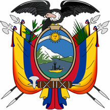
Coat of Arms of Ecuador
Ecuador data:
Territorial extension: 283,561 km².
Location: South America.
Capital: Quito.
Climate: Equatorial (coastal zone) and altitude equatorial (inland).
Government: Presidential Republic.
Administrative division: 21 provinces subdivided into cantons and parishes.
Spanish language.
Religion: Christianity, 97.5% (Catholics, 92%, others, 5.5%), others, 1%, no religion and atheism, 1.5%.
Population: 13,625,069 inhabitants. (Men: 6,824,856; Women: 6,800,213).
Ethnic Composition: Euramerindians, 55%, Amerindians, 25%, Iberian Europeans, 10%, African Americans, 10%.
Demographic density: 48 inhabitants/km².
Average annual population growth rate: 1%.
Population residing in urban areas: 66.31%.
Population residing in rural areas: 33.69%.
Undernourished population: 15%.
Life expectancy at birth: 74.8 years.
Households with access to drinking water: 95%.
Households with access to a health network: 84%.
Human Development Index (HDI): 0.695 (high).
Currency: US Dollar.
Gross Domestic Product (GDP): US$44,400 million.
GDP per capita: 3,328 US$.
External relations: World Bank, Andean Community, IMF, Rio Group, OAS, WTO, UN.
By Wagner de Cerqueira and Francisco
Graduated in Geography
Brazil School Team
countries - geography - Brazil School


