Alagoas is a Brazilian state that makes up the Northeast region, with capital in the city of Maceió. Its relief is formed by depressions and plateaus, and the climates found in the state are semiarid and tropical. The current population of Alagoas is just over 3.35 million inhabitants, the majority living in cities. At the moment, the economy of Alagoas stands out for the production of sugarcane and for the industry linked to that cultivation.
Read too: What are the states of Brazil?
General data for Alagoas
- Region: North East.
- capital: Maceió.
- Government: representative democracy, with the governor at the head of the state executive branch.
- Areaterritorial: 27,830,656 km² (IBGE, 2020).
- Population: 3,351,543 inhabitants (IBGE estimate, 2020).
- Densitydemographic: 112.33 inhab./km² (IBGE, 2010).
- spindle: Brasília Standard Time (GMT -3 hours).
- Climate: semiarid and tropical.
Do not stop now... There's more after the advertising ;)
Alagoas geography
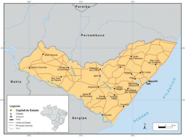
The state of Alagoas is located in the Northeast Region and has Maceió as its capital. It has a surface of 27,830.65 km²,
the third smallest among the federative units (considering the Federal District).To the east, the territory of Alagoas has an exit to the Atlantic Ocean, with a coastal strip of 229 km. Borders:
- to the north, with Pernambuco;
- to the west, with the Bahia; and
- to the south, with Sergipe.
The state is further divided into three of the four sub-regions of the Northeast, namely: the Sertão, the Agreste and the Zona da Mata, from west to east in the same sequence.
Alagoas climate
two weather types are predominant in Alagoas. The first is the semiarid, which covers the entire west of the state. It is characterized by low levels of air humidity linked to high temperatures and long periods of drought. The average annual rainfall varies between 400 and 600 mm in the Sertão. In the Agreste, this index can reach 900 mm.
The second climate is the tropical wet, which prevails in the lands situated to the east. Like the first one, it is marked by high temperatures, which vary between 23º C and 28º C (with the exception of high areas, where conditions are milder), but it presents rains more abundant and greater humidity in the air. The average rainfall is 1,000 mm to 1,600 mm annually, exceeding 1,900 mm in some coastal areas.
Alagoas relief
The relief of Alagoas is predominantly formed by depressions and plateaus, with an average altitude of 300 meters.
To the west of the territory, according to the classification proposed by Jurandyr Ross, the characteristic features of the San Francisco Depression, where it is also possible to find isolated areas of higher altitude. To the north and northeast extends the Borborema Plateau, while to the east are the Coastal Plains and Tablelands. The highest point of Alagoas is in Serra da Onça, located 1,016 meters above sea level.
Alagoas Vegetation
The vegetation cover of Alagoas is formed by species characteristic of two biomes:
- Caatinga, which extends to the west of the state and is characterized by deciduous trees (which lose their leaves in the dry season), xerophytes, shrubs and grasses;
- WoodsAtlantic, to the east, composed of forests.
The coastal wetlands are covered with coastal vegetation such as mangroves and restingas.
Alagoas Hydrography
The Alagoas drainage network belongs to the basins of São Francisco River (west) and the Eastern Northeast Atlantic (east). Among its main water courses are the Mundaú, Camaragibe, Coruripe, Ipanema, Manguaba and São Francisco rivers.
See too: What are the hydrographic basins in Brazil?
Alagoas map
Alagoas Demographics
The state of Alagoas has 3,351,543 inhabitants, according to the estimates of the IBGE for 2020. This total is equivalent to 5.8% of the population of the Northeast Region and 1.5% of the Brazilian population. the territory is densely populated, with a population distribution of 112.33 inhab./km² at the time of the 2010 census. With current data, it is estimated that the demographic density of Alagoas is 120.42 inhab./km².
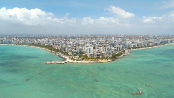
Most of Alagoas live in urban centers, being the state urbanization rate of 73.63%. Maceió is its most populous city and the 14th capital in population in Brazil, with 1,025,360 inhabitants. Next is Arapiraca, which has 233,047 residents. Pindoba is the least populous municipality in Alagoas, with 2,905 inhabitants.
The state's recent population growth rate was 0.42% (between 2019 and 2020), lower than the national one (0.77%). The capital of Alagoas alone was responsible for almost half of the number of new residents, which was just over 14,000. It is noteworthy that the state registers today low life expectancy (72.7 years), compared to the country average.
Alagoas geographic division
The territory of Alagoas is divided by IBGE into immediate geographic regions and intermediate geographic regions. Therefore, the 102 municipalities in the state are grouped into 11 immediate regions, which are divided into two intermediate regions this way:
-
Maceió (east of the state):
- Ponto Calvo – São Luís do Quitunde;
- Maceio;
- São Miguel dos Campos;
- boulder;
- Union of Palmares;
- Watchtower.
-
Arapiraca (center and west of the state):
- Arapiraca;
- Palm Tree of the Indians;
- Delmiro Gouveia;
- Santana do Ipanema;
- Pão de Açúcar – Olho d'Água das Flores – Batalha.
Alagoas Economy
The Gross Domestic Product (GDP) of Alagoas is R$ 54.41 billion, which corresponds to a share of 0.8% of the Brazilian economy. Taking into account all federative units, the state is in 20th place. The largest portion of the added value corresponds to the tertiary sectoror services. Disregarding public administration, its share is 44.65%. Agriculture is responsible for 16.62%, while industry is responsible for 12.01%.
The state's agriculture is led by sugarcane cultivation, being Alagoas one of the ten largest national producers, and also by bovine breeding. Therefore, milk is among the main products from the primary sector. Agriculture in Alagoas is also composed of rice, corn, beans, cassava, banana and orange crops.
Following primary production, the sugar and alcohol sector is part of the transformation industry in Alagoas. The extraction of Petroleum and natural gas for the production of fuels and other derivatives, such as rubber and plastics. The state's industry is also made up of civil construction, the flagship of the secondary sector, food, utilities, beverages and non-metallic minerals.
See too: Causes and consequences of poverty in Brazil
Alagoas Government
The government of Alagoas is a representative democracy. The population elects its governors through state elections, which are held periodically, at an interval of four years. The state executive branch is headed by the governor. The Legislative of Alagoas, in turn, is formed by 3 senators, 9 federal deputies and 27 state deputies.
Alagoas Flag

Alagoas Infrastructure
With the majority of the population living in urban areas, the Alagoas electrification network covers almost all households in the state. Access to treated water and the sewage system, however, is significantly lower. In 2019, 75.4% of the population had access to the water network, a higher rate in cities (89.5%). The sewage network served 28.6% of the urban population and only 15.6% of the generated sewage was treated, showing a serious bottleneck in the state's basic sanitation services.
The energy matrix of Alagoas is composed, in its majority, by renewable sources, led by sugarcane bagasse. Hydraulics are the second largest energy generating force in the state, followed by sugarcane juice and natural gas. Due to the high incidence of solar rays during most of the year, solar energy has been gaining more and more space in the Alagoas matrix.
You transport is mainly carried out by highways.. Among them are the BR-101, BR-110, which crosses part of the Northeast, from Rio Grande do Norte to Bahia, BR-104 and BR-116. The main port of the state is in the capital, which is the Port of Maceio. The Zumbi dos Palmares International Airport is used by around two million people each year and is also responsible for cargo transportation.
Alagoas Culture
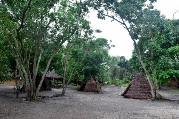
The state of Alagoas has a rich culture, formed from the influence of indigenous peoples, Europeans and Africans. Among the most popular forms of cultural manifestation in the state are handicrafts, such as embroidery, and handicraft made with raw materials, such as banana fiber, straw, coconut husks, wood and others.
Some of popular parties of the state are: Reisado, Cavalhada, Guerreiro, Caboclinhos, Festa do Mar, Peja and others. Alagoas gastronomy has a wide variety of preparations, many of which include seafood in their recipe. One of the typical dishes of Alagoas is sururu de capote, made with part of the shellfish in the shell and coconut milk.
In addition to the beautiful beaches and natural landscapes that are great tourist attractions, such as Maragogi, Alagoas has historical places listed as cultural heritage of Brazil. One of them is the Serra da Barriga, also considered a heritage of the Mercosur in 2017. It was there that the headquarters of the Quilombo dos Palmares, between the end of the 16th century and the 17th century, considered the largest quilombo in the country and in Latin America.
History of Alagoas
The 16th century was marked by the arrival of the Portuguese in Brazil from the northeastern coast, a region inhabited at the time by several indigenous populations. The expeditions included the current state of Alagoas. The area also awakened the interest of other European peoples, such as the French, which ended up settling on the coast of Alagoas in the same period. The Portuguese managed to regain control of the land in 1535, under the leadership of Duarte Coelho.
You Dutchmen, in turn, they arrived in the Northeast almost a century later, in 1630, advancing through the territory of Alagoas. After numerous direct conflicts, the Dutch were finally expelled from the region in the year 1645.
During this same period of time, another important episode in Brazilian history was unfolding in the Zona da Mata of Alagoas. A large number of people enslaved in the sugar mills of the then captaincy of Pernambuco fled and formed the Quilombo dos Palmares, in Serra da Barriga, in Alagoas. The quilombo had about 20 thousand inhabitants and was led by Zombie, becoming a great symbol of resistance of African populations in Latin America. A target for both the Portuguese and the Dutch, Palmares was destroyed in 1694.
The territory of Alagoas was elevated to the status of captaincy in 1817, being until then a district. It became a state from the Pproclamation of the republic, an act performed by Deodoro da Fonseca, from Alagoas, in 1889. Two years later, in 1891, its first state constitution was promulgated in Alagoas.
By Paloma Guitarrara
Geography teacher