
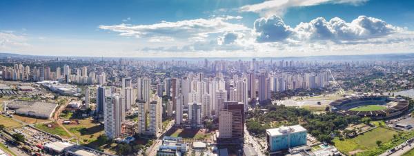
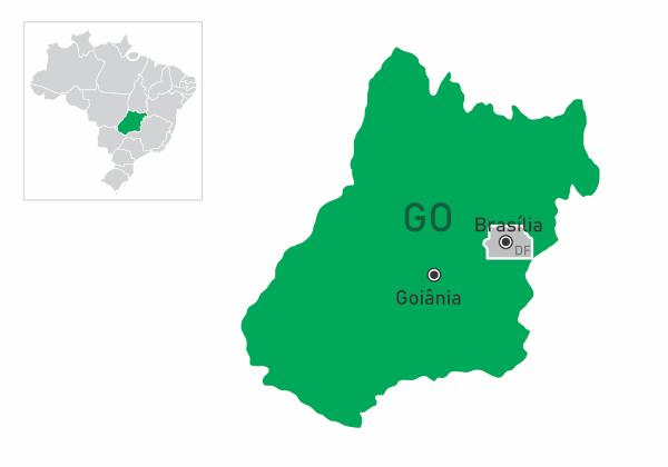
Goiania is a Brazilian municipality located in the Midwest region. Belongs to the state of Goiás and performs the function of capital, thus being its administrative center. The city is, in addition, one of the main state economic centers, standing out in the activities developed by the tertiary sector of the economy. With a semi-humid tropical climate, Goiânia integrates the Brazilian central plateau and is located in the Cerrado area. It currently has more than 1.5 million inhabitants.
Read too: What are the capitals of Brazilian states?
General data for Goiania
Gentile: Goiás
-
Location
Parents: Brazil
Federative unit: Goiás
Intermediate region: Goiania
Immediate region: Goiania
-
Metropolitan region: Metropolitan Region of Goiânia (RMG)
Formed by the following municipalities: Goiânia, Abadia de Goiás, Aparecida de Goiânia, Aragoiânia, Bela Vista de Goiás, Bonfinópolis, Brazabrantes, Caldazinha, Caturaí, Goianápolis, Goianira, Guapó, Hidrolândia, Inhumas, Nerópolis, Nova Veneza, Santa Bárbara de Goiás, Santo Antônio de Goiás, Senador Canedo, Terezópolis de Goiás and Trinity.
Bordering municipalities: Nerópolis, Goianápolis, Senator Canedo, Aparecida de Goiânia, Aragoiânia, Abbey of Goiás, Trindade, Goianira, Santo Antônio de Goiás.
-
geography
Total area: 728.841 km² (IBGE, 2020)
Total population: 1,536,097 inhabitants (IBGE, 2020)
Demographic density: 1,776.74 inhab./km² (IBGE, 2010)
Climate: semi-humid tropical
Altitude: 749 meters
Timezone: GMT -3
-
Historic
Foundation: October 24, 1933
Do not stop now... There's more after the advertising ;)
Goiania geography
Goiania is a Brazilian municipality located in Midwest region of Brazil. It is part of the federative unit of Goiás, playing the role of state capital by housing the seat of the state government. It is the main city in the Metropolitan Region of Goiânia, currently comprising 21 municipalities. The territory of Goiás is bordered by nine other cities, namely:
Neropolis, to the north and northeast;
Goianápolis and Senador Canedo, to the east;
Aparecida de Goiânia, to the southeast;
Aragoiania, to the south;
Abbey of Goiás, to the southwest;
Trinity to the west;
Goianira and Santo Antônio de Goiás, to the northwest.
The extension of Goiânia is 728.841 km², the 14th Brazilian capital in area. It is located approximately 200 km from the federal capital, Brasilia. Below we highlight other important physical characteristics.
Goiania climate
The predominant climate in Goiânia is the Ttropical semi-wet, characterized by two well-defined seasons: a summer hot and humid and a Winter mild and dry. THE average annual temperature is around 23 ºC, while the minimum and maximum range between 15 ºC and 31 ºC. The rainy season runs from October to April, and rainfall exceeds 1500 mm per year.
See too: What is the difference between weather and climate?
Goiania relief
According to the classification of the Brazilian relief established by Aziz Ab’Sáber, the lands that make up Goiânia are part of the Central Plateau. The city is located at an average altitude of 749 meters, and has a relief that varies between wavy and flat, consisting of shapes such as plateaus, hills and plains. The Mendanha hill is the highest point in the capital of Goiás, located 841 meters above sea level.
Goiania Vegetation
Located in the center of the national territory, Goiânia falls within the scope of the biome thick. The natural vegetation of this domain consists of grasses, shrubs and trees with twisted branches. Part of the original coverage can be seen in some of the city's parks and woods.
Goiania Hydrography
Only one river crosses the city, which is the Meia Ponte. This river is one of the tributaries of the Paranaíba River, which, in turn, forms one of the most important hydrographic basins in Goiás. In total, the capital of Goiás has 85 water courses, which, in addition to the Meia Ponte River, are divided into streams and streams. There are four: Anicuns, Capivara, Dourados and João Leite.
Goiania map
Demographics of Goiania
Goiânia is the most populous city in the state of Goiás, bringing together a population of 1,536,097 inhabitants. It is also part of the list of the largest Brazilian capitals in 10th place. It represents the second largest urban concentration in the state, with a density of 1776.74 inhab./km². Thus, Goiânia can also be considered a highly populated city.
Its metropolitan region concentrates approximately 36% of the entire population of the state, and the capital alone represents almost 60% of all residents of the RMG.
According to the latest IBGE Census, 99.6% of the homes in Goiás are located in urbanized areas. Also according to the same survey, the vast majority of the population declares themselves white (47.95%) or brown (44.52%), while 5.68% declare themselves black, and less than 2%, yellow and indigenous. Regarding age composition, there is a large concentration of people between 20 and 39 years old.
Based on parameters such as education, income and health, the Human Development Index (HDI) in Goiânia is 0.799, which is considered high and the highest in Goiás. On a national scale, the city ranks 45th.
Read too: The 20 most populous cities in the world
Geographical division of Goiânia
The municipality of Goiânia is located divided into 680 neighborhoods and sectors. Each of these units belongs to different regions, which currently total seven and are named according to their geographic position. Are they:
center
North
Northwest
West
East
South
South-west
Goiania Economy
Goiânia is the main economy of Goiás and the 10the richest capital in Brazil. In addition, the city stands out as the 16th on a national scale, according to the IBGE. Your Gross Domestic Product (GDP) is R$49.36 billion, equivalent to a quarter of the state GDP.
The economy of Goiás was, a few decades ago, guided essentially by the primary sector, with emphasis on agricultural activities that gained greater strength with the advance of agricultural frontier to the Cerrado in the second half of the 20th century. However, this picture changed significantly, and nowadays the sector tertiary, which covers commerce and services, with the exception of public administration, accounts for about 70% of the municipal GDP.
O secondary sector, formed by the industry, is responsible for a 14.6% share of the Goiás economy, and has greater strength on a local than regional scale. The productive branches that stand out are pharmaceuticals, food, construction, and textiles. The contribution of agriculture is smaller and adds less than 1% to the municipal economy. Among the main products are tomatoes, corn, cassava, soy, rice, as well as cattle and poultry.
Goiania Government
The government of Goiânia is of the type representative democratic. The governors of the municipality are chosen by the citizens of Goiás every four years through municipal elections. The municipal Executive Power is head of the Mayor. The Legislative Power, in turn, is represented by the City Council, currently composed of 35 councilors.
The city also plays the role of state capital. This means that it houses the seat of the government of the state of Goiás, whose main activities and functions are concentrated in the Pedro Ludovico Teixeira Palace.
Goiania Infrastructure
Goiania has a high HDI, a factor associated with the good quality of life that the city has. Another aspect of the capital of Goiás that contributes to this characteristic is its extensive green areas, whose availability meets the international parameters established by the United Nations for urban areas, which is greater than 12 m² per inhabitant. According to data from the city of Goiânia, this index reaches 94 m² in the city.O IBGE points out that the afforestation of public roads is 89.3%.
Most of the city's homes are located in urbanized areas. Adequate sanitary sewage has a coverage of 76.1%, with the majority being serviced by the garbage collection service. Approximately 93% of the homes in Goiânia are connected to the municipal water supply network, while electricity supplies 99.9% of homes.
Located in the center of Brazilian territory and about 200 km from the federal capital, Goiânia has an extensive transport network that connects it with all other regions of Brazil. In addition to the important federal and state highways that pass through the city, national and international connections are made by Goiania International Airport (Santa Genoveva), the principal of the state.
Goiania Culture
![Oscar Niemeyer Cultural Center, in Goiânia. [1]](/f/f82dee4acf3be1bdb12c8e522c28cc54.jpg)
THE culture is from Goiás quite heterogeneous and composed by the influence of the customs and traditions of the peoples that formed the city and state of Goiás, notably Portuguese, Africans and migrants from other Brazilian regions.
A large part of its cultural and also natural heritage is preserved in museums such as the Museum of Image and Sound, the Museum of Art of Goiânia and the Cerrado Museum, for example. Popular access to culture is expanded through the numerous fairs held in the city, through installed libraries, theaters and also through the centers cultural, such as the Oscar Niemeyer Cultural Center, whose building was designed by the architect himself and preserves in its own structure a tribute to several local artists.
Restaurants, bars, squares, parks and woods represent spaces for recreation and socialization arranged by the city, in the same way as the municipal markets, which concentrate, in addition to the usual goods, events and leisure areas.
Among the municipal holidays is the city's birthday (24/10) and the day of the patron saint of Goiânia, Nossa Senhora Auxiliadora (24/05).
See too: material culture and immaterial culture
History of Goiania
The history of Goiânia and its status as the capital of Goiás is directly associated with the cycles economic factors experienced by the region, called, at the time, the province of Goiás, between the 18th and XIX.
Let us remember that the current state and territory of the Tocantins they formed a single unit, and there was an attempt to transfer the provincial capital from the lands located further north to the south-central portion, where the current city of Pirenópolis is located. Discussions lasted between 1753 and the entire nineteenth century, with the region's economy and the decline of gold activity in the north, until then the economic base of the province of Goiás, as its main argument.
The depletion of deposits gave greater emphasis to agro-pastoral activities, which became the flagship of the economy of Goiás. Located in areas more prone to these practices, southern cities gained greater prominence in the regional scenario. Despite that, the city of Goiás was maintained as the state capital.
The change in this picture came from the 1930s, when allied to the occupation policies of the national territory developed by Getúlio Vargas, the west march, to the political context of the time. The then president appointed the intervener Pedro Ludovico Teixeira, who, among other decisions, established the move to the capital of Goiás.
Analyzes of the sites began in 1932, and, in the following year, the urban project began to take shape. The selected location corresponds today to the current neighborhood of Campinas, and the foundation stone of Goiânia was laid on October 24, 1933. Since then, new areas have been annexed, and Goiânia has been expanding. The greatest urban and population growth took place from the 1950s onwards, with the new national policies for the integration of the national territory and the transfer of the federal capital to the region, northeast of Goiânia.
Image credit
[1] Wagner Santos de Almeida / Shutterstock
By Paloma Guitarrara
Geography teacher