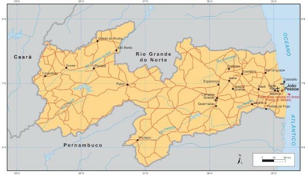
THE Paraíbais one of the Brazilian states that make up the RNortheast region. Located between Ceará, Rio Grande do Norte and Pernambuco, the state is composed of landforms that characterize the Sertaneja Depression and the Borborema Plateau, in addition to the coastal plain to East.
Both Predominant climatic types are semi-arid and hot and humid tropical. Paraíba's economy is led by the tertiary sector, followed by industry, especially civil construction and the production of leather and shoes. In agriculture, sugarcane stands out.
See too: What are the capitals of Brazil?
General data for Paraíba
Region: North East.
capital: João Pessoa.
Government: representative democratic, with the governor at the head of the state executive branch.
Areatterritorial: 56,467.242 km² (IBGE, 2020).
Population: 4,039,277 inhabitants (IBGE, 2020).
Densitydemographic: 66.70 inhab/km² (IBGE, 2010).
spindle: Brasília Standard Time (GMT -3 hours).
Climate: semi-arid and tropical hot and humid.
Paraíba geography
Paraíba is a Brazilian state located in the Northeast Region.
It has an Atlantic coastline, where its capital, João Pessoa, is located.. To the north, the territory of Paraíba borders the large northern river; to the west, with the Ceará; and to the south, with Pernambuco. With an area of 56,467 km², is the seventh smallest state in Brazil.The Northeast of Brazil is divided into four sub-regions, and the territory of Paraíba is inserted in three of them:
- the northeastern Sertão, which covers the western half of the state;
- the Agreste, in a central strip; and
- the Zona da Mata, to the east.
Do not stop now... There's more after the advertising ;)
Paraiba climate
Two climatic types are predominant in Paraíba: o semiarid, which is distributed in the western portion of the state, and the tropical hot and humid, which is mainly concentrated in regions close to the coast.
The first is characterized by an irregular rainfall regime and variable dry periods. The average annual rainfall is between 250 and 750 mm. The second is also marked by the high temperatures, summers relatively dry, and autumns and winters rainy, with rates that can exceed 1500 mm.
Relief of Paraíba
Paraíba is inserted in three morphological units. The first of them, which corresponds to the western lands, is the Sertaneja depression. The second is the Borborema Plateau, which extends through the central portion of the state and also along a longitudinal strip on the southwestern border with Pernambuco. The highest point in the state is located in Borborema, Pico do Jabre, with 1,197 meters. Finally, we have the chessboards and the coastal plain, in the far east of Paraíba.

Vegetation of Paraíba
The coast of Paraíba is part of the biome Atlantic forestand, for this reason, it has characteristic vegetation, which varies from coastal to large trees, although the forest is quite reduced due to agricultural activity. Next, there is a transition range (Agreste) for the Caatinga, to the west, marked by small to medium-sized species adapted to the dry climate.
Paraíba Hydrology
The state is divided into eleven watersheds, of which the Piranhas-Açu River and Paraíba River basins stand out, which correspond to more than 80% of the total area of the state.
See too: Amazon Basin — one of the greatest water potentials in the world
Map of Paraíba
Demographics of Paraíba
Estimates of the IBGE for 2020 indicate that the Paraiba population is 4,039,277 inhabitants, being the 5th state in terms of population in the Northeast Region. According to the 2010 Census, the population density was 66.7 inhabitants/km², when the survey was carried out. Currently, this number is 71.53 inhab/km².
Most of the population of Paraíba lives in urban centers. Taking into account the last census, the state's urbanization rate is 75.3%. The most populous municipality is the capital, João Pessoa, which has 817,511 inhabitants. Next is Campina Grande, with 411,807. The least populated city is Parari, with 1,758 inhabitants.
Population growth in 2020 was 0.52% for the state. The capital, in turn, grew three times more than the set of municipalities. Life expectancy at birth is 74.1 years, somewhat lower than the national average (76.6).
Paraíba geographic division
The state of Paraíba is made up of 223 municipalities. These make up different immediate geographic regions, according to the division established by IBGE as of 2017. Altogether, the territory of Paraíba is divided into 15 immediate regions.
The immediate regions, in turn, are grouped into intermediate geographic regions. Paraíba has four of these subdivisions, which are established from east to west in the following sequence:
Sousa-Cajazeiras,
Ducks,
Campo Grande and
João Pessoa.
Economy of Paraíba
According to IBGE data (2018), O Gross Domestic Product (GDP) of Paraíba is BRL 64.373 billion, composed mostly by the tertiary sector, from which trade and services stand out. Industry represents 15.47% of the total value added to the GDP of Paraíba, while the primary sector accounts for 3.96%.
color building constructionresponds à biggest share of industrial GDP of State. Next, in addition to public utility services, there is the production of shoes and leather, the industry food, products derived from non-metallic minerals, the petrochemical industry and also sugar and alcohol.
THE agricultural activity in Paraíba has as its flagship sugarcane. The state is also a producer of pineapples, bananas, corn, beans, rice, cassava, herbaceous cotton and tomatoes. With regard to animal husbandry, meat and milk production, through goat and cattle herds, and egg production stand out.

Government of Paraíba
The government of Paraíba is of the representative democratic type. The executive branch of the state is headed by the governor, elected by the citizens every four years. In the Legislative, representation in the Senate is currently made by three federal senators. For the Chamber, they were elected 12 federal deputies and 36 state deputies.
Flag of Paraíba

Infrastructure of Paraíba
Paraíba is the penultimate northeastern state traversed by BR-101. This federal highway crosses the entire east coast of Brazil, going from Rio Grande do Sul to Rio Grande do Norte. Another important federal road that cuts through the Brazilian territory from North to South also passes through the state, this time in the western portion, is to BR-116. THE Trans-Amazonian (BR-230) connects Paraíba to the interior of Amazonas.
The two main airports in the state are in the capital, João Pessoa, and in the municipality of Campina Grande.
When it comes to electricity generation, the Paraíba has very high wind potential. In 2020, the state had 632 generators, of which 45 were in operation. Also noteworthy is the presence of photovoltaic parks for the production of solar energy. Currently, four are in operation and one park is under construction.
See too: What are alternative energy sources?
Culture of Paraíba
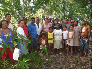
The state of Paraíba has a vast culture, which manifests itself in the most diverse forms, such as dance, literature, music, crafts and theater.
One of the most traditional parties in the state is Saint John of Campina Grande, known as the largest in the world. The state celebrates the day of its patron saint, Nossa Senhora das Neves, on November 5th.
In literature and in academia, some nationally and internationally known names have roots from Paraíba. Among them, we can mention the economist Celso Furtado, as well as the writers:
Arian Suassuna,
Augusto dos Anjos and
José Lins do Rego.
Important names in Brazilian music, of varied styles, also have their origins in the state, such as Chico César, Zé Ramalho, Elba Ramanho, Geraldo Vandré and Hebert Vianna.
When it comes to gastronomy, some typical dishes from Paraíba are rubacão (similar to baião de Dois), bolo de bolo, mungunzá, corn and cassava couscous, jerky and many others.
History of Paraíba
At the beginning of the Brazilian colonial period, the current territory of Paraíba was part of the Captaincy of Itamaracá, which was later dismembered and gave rise to the Captaincy of the Rio Paraíba.
The Captaincy of Itamaracáwent through three different grantees before the separation, which took place in 1534. The first expedition that aimed to conquer the Captaincy of the Paraíba River took place a few more decades. late, in 1574, led by Fernão da Silva and interrupted by conflicts with the indigenous population local.
The next expeditions, organized in 1575 and 1579, did not reach the area due to the weather conditions: a the first was affected by strong winds, while the second suffered severe damage due to rain intense. Frutuoso Barbosa, who was at the head of the 1579 expedition, made another attempt three years later, also frustrated by the clash with the native population and the French invaders who found themselves in Paraíba in this time course.
The Portuguese managed to install themselves in the captaincy in the year 1584, a decade after the first expedition. The construction of the city of Nossa Senhora das Neves, now João Pessoa, in 1585, consolidated the foundation of Paraíba. Its name is derived from the homonymous river and was composed of two words in the Tupi language: pa’ra (= river) and a’iba (= difficult to navigate). With the Proclamation of the Republicin the year 1889, Paraíba officially became a state.
By Paloma Guitarrara
Geography teacher