
O Maranhão is a Brazilian state located in Northeast region of Brazil. your territory was object of dispute between several European peoples, and the Portuguese maintained their dominance of the region. The culture of Maranhão is the result of the influence of the populations that occupied the state throughout its colonization. Its capital, São Luís, has a very well preserved historic centre. The population of Maranhão is concentrated on the coast and in medium-sized cities in the interior of the state.
The government of Maranhão is composed of the executive, legislative and judicial spheres. The state has low social indicators. Its economy is anchored in the primary productive sector. However, despite the economic difficulties, Maranhão has an important transport network that boosts the export of local goods. The state also has great natural beauty due to its diverse geography, which is a driving factor for tourism in the region.
Read too: States of Brazil - federative units with autonomous governments
Maranhão general data
- Region: North East
- capital: St. Louis
- Areaterritorial: 329,651 km² (IBGE, 2019)
- Population: 7,114,598 inhabitants (IBGE, 2020)
- Densitydemographic: 19.81 inhab./km² (IBGE, 2010)
- spindle: UTC -3
- Climate: tropical
Do not stop now... There's more after the advertising ;)
History of Maranhão
The current territory of the state of Maranhão was the object of dispute between several European peoples, such as the Portuguese, Spanish, French and even the Dutch. The first record of European occupation in the state dates back to 1500, through the arrival of Pathfinders from Spain. However, only in 1612 was the first urban nucleus consolidated, through the French occupation, which founded the current state capital, São Luís.
In the same period, the Portuguese occupation was advancing on Brazilian territory. Thus, in 1615, Portugal effectively occupied the Maranhão region, by expelling foreign invaders. In 1621, the state of Maranhão was created by the Portuguese.
The main purpose of installing this captaincy it was to establish the largest Portuguese domain in the region and, in particular, to prevent further foreign invasions. Even so, in 1641, forces from the Netherlands invaded the capital, São Luís, an invasion that was quelled by Portuguese forces. Through agreements between Portugal and the Netherlands, the issue was overcome.
In 1654 the states of Maranhão and Grão-Pará were created., which comprised, in addition to the territory of Maranhão, a vast area of the current state of Pará. The separation between both states was only completed in 1772.
![The historic center of the capital of Maranhão, São Luís, is very rich and representative of local historical processes.[1]](/f/b647fad84ef09565ae519282540c9f26.jpg)
The nineteenth century was marked by the urban and economic expansion of Maranhão. The state has established itself as an important political and cultural center in the mid-north of Brazil, especially its capital, São Luís, which still has an important historic center that preserves the architectural remains of this time course.
In the farming, the state stood out in the production of sugarcane and cotton. However, with the economic and political changes in Brazil in the late nineteenth century, Maranhão experienced a long period of economic stagnation and increased social vulnerability. Currently, despite the social advances of the last decade, it is considered one of the poorest states in Brazil.
Read too: Dutch invasions in Brazil - occupation of northeastern Brazil by the Dutch
Geography of Maranhão
Maranhão is located in the Northeast region of Brazil. It is bathed by the Atlantic ocean and make currency with the states:
- Piauí
- Tocantins
- For
Your geographic position represents a transition area between the northeastern and Amazon regions of the Brazilian territory. In this way, it presents a great natural diversity in its landscape.
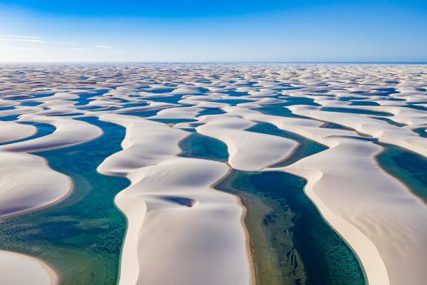
The relief from Maranhão is formed by a extensive area of flat land coastal and by regions of Highland inside the state. In lowland areas, low altitude regions are predominant, formed by sediment deposits, such as dunes, as well as marshy areas. Plateau regions, on the other hand, have higher relief formations, such as the chapadas, which are very common in Maranhão.
The climate in Maranhão is predominantly Tropical, influenced by the maritime nature and also by the humidity coming from the Amazon region. The state's main watercourses are the Parnaíba, Tocantins and Gurupi rivers, which even mark the border between Maranhão and other states.
Already the vegetation in Maranhão is extremely diverse. In the state are found formations:
- in mangel, in coastal areas
- in mminutes of çhollow, in the eastern and central portion of the state
- in Amazon rainforest, in the western portion of the state
- in thick, in the south of Maranhão
The two trees that are symbols of Maranhão are the babassu and carnauba palm trees.
Maranhão Map

Geographical division of Maranhão
Maranhão has 217 municipalities, which are divided into intermediate and immediate regions, according to regionalization criteria adopted by the Brazilian Institute of Geography and Statistics (IBGE). the state has five intermediate geographic regions and 22 immediate geographic regions. Are they:
Intermediate geographic regions |
immediate geographic regions |
St. Louis |
St. Louis |
Pine | |
Chapadinha | |
Itapecuru Mirim | |
Viana | |
little barriers | |
Tutóia-Araioses | |
Cururupu | |
Santa Ines-Bacabal |
Santa Inês |
Bacabal | |
Governor Nunes Freire | |
Quarries | |
Caxias |
Caxias |
timon | |
Codo | |
President Dutra |
President Dutra |
São João dos Patos | |
Hills | |
Empress |
Empress |
Rope Bar | |
Açailândia | |
Ferries |
Source: IBGE.
Demographics of Maranhão
The state of Maranhão has little more than seven million inhabitants. The population of Maranhão lives predominantly in urban areas, close to the coast and in medium-sized cities in the interior. However, the percentage of rural population is still one of the highest among Brazilian states. The population of Maranhão was formed by the descendants of the various European peoples who pioneered the region, as well as by traditional indigenous peoples and also by Africans.
the state presents demographic growth indicators, however it has high infant mortality rates as well as a low life expectancy. The largest city in the state is São Luís, the only city in Maranhão with more than one million inhabitants. In addition to the capital, the cities of Empress, São José do Ribamar, Timon, Caxias, Codó, Paço do Lumiar, Açailândia and Bacabal have more than 100,000 inhabitants.
See too: What are the 20 most populous cities in the world?
Maranhão Economy
Maranhão's economy is concentrated on primary sector. In agriculture, soy, cotton, rice and cassava stand out. In addition, there is the growth of extensive cattle raising, mainly in the south of the state. Extractivism is the main branch of the state primary sector, and the exploration of babassu and carnauba palms is one of the main economic activities in the state.
In addition, there is mineral extraction and wood production. Maranhão is one of the country's leading mineral exporters, due to the transport structure present in the state, which allows the movement of ores produced in Pará for sale in the ports of Maranhão.
Osecondary sector is anchored in the transformation of primary goods. The main industries are mineral transformation, food, wood and cellulose. already in the tertiary sector commercial and service activities stand out, with an emphasis on logistics. In addition to these, the tertiary sector has been growing in relation to tourism. The historical center of the capital São Luís, the Lençóis Maranhenses National Park and the Chapada das Mesas National Park are important points of tourist exploration in Maranhão.
Government of Maranhão
The form of government in Maranhão is anchored in the Three Powers. Thus, there is the Executive Branch, centered on the figure of the governor and his management team; the Judiciary Branch, represented by the state justice units; and also the Legislative Power, composed of deputies and senators. The state of Maranhão has 18 federal deputies, three senators and 42 state deputies.
Maranhão Flag
Maranhão Infrastructure
The state of Maranhão presents great differences between the state's infrastructure and the provision of basic services to the population. The state experienced, in the last decades, an important economic and social growth, but still has low quality of life indicators. With regard to infrastructure, Maranhão has become a important logistical center in the Brazilian mid-north.
The state has modern transportation equipment, which allows the state to be connected to other regions of the country and to export products by sea. The São Luís-Teresina, Norte-Sul and Carajás railways, and the Belém-Brasília and Transamazônica highways stand out. The Port of Itaqui is one of the most important seaports in Brazil, being responsible for a good part of the export of ores from the north of the country abroad.
The state it also has modern energy and telecommunications equipment. The energy sector in Maranhão is extremely diversified and has great exploration potential, either with energys renewable, be with fossil fuels.
With regard to social services, Maranhão presents low coverage of water and sewage networks. The state has low social indicators, such as high illiteracy rate and low income generation rate. Health and education, despite the expansion of coverage, still have many structural problems. In the same way as Brazil, Maranhão presents as a chronic problem the great social inequality, even more present in the isolated communities of the state.
Maranhão Culture
Maranhão has a very rich and diverse culture marked by the influence of the people who formed the state. Architecture, especially in the cities of Alcântara and São Luís, has great historical wealth. the adornments with portuguese tiles are characteristic of the historic buildings of Maranhão. The Portuguese influence is also noticeable in folk festivals and manifestations, such as religious festivals. THE Feast of the Divine is very traditional in several cities in Maranhão, as well as the June festivities and boi-bumbá.
![The streets adorned with little flags, the historic houses with tiles on the façade and the boi-bumbá festivities are typical of Maranhão.[2]](/f/1f3c95d5511333ebc63a93e933b2e3b1.jpg)
The state also cultivates diverse musical genres, with emphasis on the reggae. The handicraft from Maranhão uses the leaves and fruits of the palm trees, which are abundant in the state. In cooking, foods such as seafood, various seasonings, cassava and juçara, also known as açaí, are used.
Image credits:
[1] Stefano Ember / Shutterstock
[2] Ksenia Ragozina / Shutterstock
by Matthew Campos
Geography teacher
