Made up of more than 300 islands in the Pacific Ocean, located in the northwestern portion of Oceania, the Republic of Palau integrates the archipelago of the Carolinas, with the Federation of Micronesian States.
The territory has already been occupied by several countries: Spain, Germany, Japan and the United States (which carried out several nuclear tests in the Micronesia region). After holding a referendum in 1978, the country obtained its autonomy, however, the Americans are responsible for defense and national security.
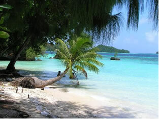
Endowed with beautiful natural landscapes, the territory of Palau has a coastline with translucent waters, housing the richest coral and marine life on the planet, with 1,500 species of fish and 700 types of coral.

Palau beach
The natural beauty attracts many tourists, which, together with financial aid from the United States and fishing, is the main source of income in the country. Other important elements for the economy are: coconut, cassava and banana production.
The population contingent is 20,300 inhabitants and most reside in urban areas (81.7%). The infant mortality rate is 9 for every thousand live births; the illiteracy rate is 8.2%.
Do not stop now... There's more after the advertising ;)

Palau Coat of Arms
Palau data:
Territorial extension: 459 km².
Location: Oceania.
Capital: Melekok.
Tropical weather.
Government: Presidential Republic.
Administrative Division: 16 states.
Languages: English and Palauense (official), regional languages.
Religions: Christianity 95.2% (Catholics 43.1%, Protestants 30.2%, Independents 15.2%, others 6.7%), others 2.5%, no religion 2.3%.
Population: 20,397 inhabitants. (Men: 10,939; Women: 9,458).
Composition: Palauans 83.2%, Filipinos 9.8%, Micronesians 2%, Chinese 1.2%, Southern Europeans 0.8%, other 3%.
Demographic density: 44.4 inhab/km².
Average annual population growth rate: 0.3%.
Population residing in urban areas: 81.7%.
Population residing in rural areas: 18.3%.
Life expectancy at birth: 69.4 years.
Households with access to drinking water: 89%.
Households with access to the health network: 67%.
Currency: US Dollar.
Gross Domestic Product (GDP): 182 million dollars.
GDP per capita: 8,376 dollars.
External relations: World Bank, IMF, UN.
By Wagner de Cerqueira and Francisco
Graduated in Geography
Brazil School Team
countries - geography - Brazil School


