You parallels and meridians they are imaginary lines drawn to define cartographically the different points of the Earth. The main function of these lines is to establish the latitudes and longitudes in order to specify the geographic coordinates from different places on the planet. They are, therefore, circles or semicircles that circle the Earth in the north-south and east-west directions.
You parallels they are the axes that imaginarily circle the planet in the horizontal direction. From them, the latitudes, which vary from -90º to 0º to the south and from 0º to 90º to the north, are measured in degrees.
There are some "special" parallels, such as the equator line. This imaginary line has the merit of having an equal distance from the two poles of the planet. In this way, everything above it represents the North hemisphere, also called boreal or northern, and everything below represents the hemisphere south, also called southern or southern. The equator is also important because it is the area of the Earth that most receives the sun's rays in the perpendicular direction, when they are strongest.
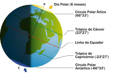
There are other important parallels: the tropics. O Tropic of Cancer, located north at latitude 23º27 (23 degrees and 27 minutes), is the line that indicates the maximum limit at which the sun's rays fall vertically on the Earth during the solstices. O Tropic of Capricorn, in turn, has the same function in relation to the southern hemisphere, with a latitude of -23º27'.
In addition to these examples, polar circles are also worth mentioning. To the north, the Arctic Circle, with a latitude of 66º33', marks the limit of the solar illumination zone over the polar regions during the solstices. The same happens with the antarctic polar circle in relation to the south, thus presenting an inverse latitude of -66º33'.
When the solstices happen, illuminating the northern hemisphere, there is the so-called "long day" in the areas located above the circle Arctic polar, with no night and leaving the regions south of the Antarctic polar circle in a long period of darkness. Six months later, the process reverses and it is the south pole that lights up and the north pole that remains in the dark.
Do not stop now... There's more after the advertising ;)
Look at the diagram below and note the importance of the mentioned parallels in measuring the accuracy of the solstices as the level of inclination of the sun's rays.

Schematic of Earth's parallels during the solstice
You meridians represent the imaginary lines drawn vertically on the terrestrial globe. In this sense, unlike what happens with the Equator, there is no more accentuated lighting zone, and therefore there is no “center” of the Earth. They are used to measure longitudes, which range from -180° to 0° west and 0° to 180° east.
At the end of the 19th century, by convention, the Greenwich Mean Time, with a length of 0º. This meridian divides the Earth vertically, thus originating the hemisphere East or Eastern, with positive longitudes, and the hemisphere West or western, with negative longitudes.
The Greenwich Meridian “cuts” the city of London in half, representing, in a way, the worldview at the time of its establishment, neatly eurocentric, that is, with Europe placed at the heart of the world.
Added to this is the function of the meridians in relation to the time zones, also counted from Greenwich. Thus, 24 axes were divided (12 to the east and 12 to the west), in which each one represents a change of one hour in relation to to the mentioned meridian, with times added when moving to the east and decreased when moving to the West.
By Rodolfo Alves Pena
Master in Geography


